Senlis geodata
Senlis (Hauts-de-France) is a seat of a third-order administrative division; located in France in Europe/Paris (GMT+2) time zone. With population of 19,160 people, there are 481 cities with bigger population in this country. Compared to other cities in France, 84.4% of cities are located further ↓South; 51.9% of cities are located further ←West and 75% of cities have higher elevation than Senlis. Note1
Administrative division(s):
- Level 1: Hauts-de-France
- Level 2: Département de l'Oise
- Level 3: Arrondissement de Senlis
- Level 4: Senlis


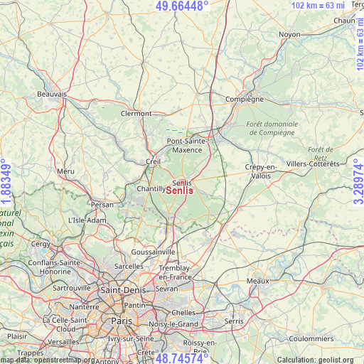
Senlis GPS coordinates[2]
49° 12' 26.064" North, 2° 35' 11.796" East
| Map corner | latitude | longitude |
|---|---|---|
| Upper-left | 49.66448°, | 1.88349° |
| Center: | 49.20724°, | 2.58661° |
| Lower-right: | 48.74574°, | 3.28974° |
| Map W x H: | 102.2×102.2 km | = 63.5×63.5mi |
| max Lat: | 51.07786° ⇑15.6% North |
| Senlis: | 49.20724° |
| min Lat: | ⇓84.4% South 41.3874° |
| min Long | Senlis | max Long |
| -5.08615° | 2.58661° | 9.52242° |
| W 51.9%⇐ | ⇒48.1% E |
Elevation
Elevation of Senlis is 67 m = 220 ft, and this is 126.7 m = 416 ft below average elevation for this country.
| Max E: |
2333 m = 7654 ft | 75% |
| Avg. | 193.7 m = 635 ft | |
| Senlis | 67 m = 220 ft | |
Min E: |
-1 m = -3 ft | 25% |
See also: France elevation on elevation.city.
Geographical zone
Senlis is located in North temperate zone (between Tropic of Cancer and the Arctic Circle). Distance of this North polar circle is 1929.8 km =1199.1 mi to North.| Distance of | km | miles | from Senlis |
|---|---|---|---|
| North Pole | 4535.7 | 2818.4 | to North |
| Arctic Circle | 1929.8 | 1199.1 | to North |
| Tropic Cancer | 2865.4 | 1780.5 | to South |
| Equator | 5471.3 | 3399.7 | to South |


Nearby cities:
15 places around Senlis: (largest is in red/bold)
• Apremont
6 km =3.7 mi,  287°
287°
• Aumont-en-Halatte
3.9 km =2.4 mi,  317°
317°
• Avilly-Saint-Léonard
3.6 km =2.2 mi,  246°
246°
• Barbery
6.1 km =3.8 mi,  74°
74°
• Chamant
2.3 km =1.4 mi,  52°
52°
• Chantilly
8.5 km =5.3 mi,  260°
260°
• Courteuil
4 km =2.5 mi, 258°
• Creil
9.2 km =5.7 mi,  306°
306°
• Fleurines
5.8 km =3.6 mi,  358°
358°
• La Chapelle-en-Serval
9.6 km =6 mi,  203°
203°
• Pontarmé
6.5 km =4 mi, 203°
• Thiers-sur-Thève
6.2 km =3.9 mi,  190°
190°
• Verneuil-en-Halatte
9.2 km =5.7 mi,  330°
330°
• Villers-Saint-Frambourg
6.6 km =4.1 mi,  36°
36°
• Vineuil-Saint-Firmin
6.7 km =4.2 mi, 263°
Sources, notices
• [Note1] Compared only with cities in France existing in our database
• [Src1] Map data: © OpenStreetMap contributors (CC-BY-SA)
• [Src2] Other city data from geonames.org with taken over terms of usage.
• [Src3] Geographical zone / Annual Mean Temperature by Robert A. Rohde @ Wikipedia
