Collinée geodata
Collinée (Brittany) is a populated place; located in France in Europe/Paris (GMT+2) time zone. With population of 973 people, there are 9041 cities with bigger population in this country. Compared to other cities in France, 64.5% of cities are located further ↓South; 96.3% of cities are located further →East and 73.5% of cities have lower elevation than Collinée. Note1
Administrative division(s):
- Level 1: Brittany
- Level 2: Département des Côtes-d’Armor
- Level 3: Arrondissement de Saint-Brieuc
- Level 4: Le Mené


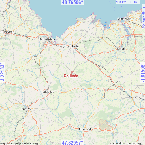
Collinée GPS coordinates[2]
48° 17' 58.056" North, 2° 31' 5.52" West
| Map corner | latitude | longitude |
|---|---|---|
| Upper-left | 48.76506°, | -3.22133° |
| Center: | 48.29946°, | -2.5182° |
| Lower-right: | 47.82957°, | -1.81508° |
| Map W x H: | 104×104 km | = 64.6×64.6mi |
| max Lat: | 51.07786° ⇑35.5% North |
| Collinée: | 48.29946° |
| min Lat: | ⇓64.5% South 41.3874° |
| min Long | Collinée | max Long |
| -5.08615° | -2.5182° | 9.52242° |
| W 3.7%⇐ | ⇒96.3% E |
Elevation
Elevation of Collinée is 239 m = 784 ft, and this is 45.3 m = 149 ft above average elevation for this country.
| Max E: |
2333 m = 7654 ft | 26.5% |
| Collinée | 239 m 784 ft | |
| Avg. | 193.7 m = 635 ft | |
Min E: |
-1 m = -3 ft | 73.5% |
See also: France elevation on elevation.city.
Geographical zone
Collinée is located in North temperate zone (between Tropic of Cancer and the Arctic Circle). Distance of this North polar circle is 2030.8 km =1261.9 mi to North.| Distance of | km | miles | from Collinée |
|---|---|---|---|
| North Pole | 4636.7 | 2881.1 | to North |
| Arctic Circle | 2030.8 | 1261.9 | to North |
| Tropic Cancer | 2764.5 | 1717.8 | to South |
| Equator | 5370.4 | 3337 | to South |


Nearby cities:
15 places around Collinée: (largest is in red/bold)
• Bréhand
12.3 km =7.6 mi,  340°
340°
• Langast
10.9 km =6.8 mi,  259°
259°
• Langourla
7.8 km =4.8 mi,  102°
102°
• Laurenan
11.2 km =7 mi,  186°
186°
• Le Gouray
3.8 km =2.4 mi,  35°
35°
• Moncontour
10.8 km =6.7 mi,  308°
308°
• Plessala
7.9 km =4.9 mi,  250°
250°
• Plémy
12.8 km =8 mi,  288°
288°
• Plénée-Jugon
11.3 km =7 mi,  50°
50°
• Saint-Glen
6.6 km =4.1 mi,  356°
356°
• Saint-Gouéno
5.1 km =3.2 mi,  226°
226°
• Saint-Jacut-du-Mené
3.2 km =2 mi,  128°
128°
• Saint-Vran
9 km =5.6 mi,  141°
141°
• Trébry
6.6 km =4.1 mi, 338°
• Trédaniel
9.9 km =6.2 mi, 311°
Sources, notices
• [Note1] Compared only with cities in France existing in our database
• [Src1] Map data: © OpenStreetMap contributors (CC-BY-SA)
• [Src2] Other city data from geonames.org with taken over terms of usage.
• [Src3] Geographical zone / Annual Mean Temperature by Robert A. Rohde @ Wikipedia
