Laboissière-en-Thelle geodata
Laboissière-en-Thelle (Hauts-de-France) is a populated place; located in France in Europe/Paris (GMT+2) time zone. With population of 1,309 people, there are 6984 cities with bigger population in this country. Compared to other cities in France, 85.9% of cities are located further ↓South; 55% of cities are located further →East and 65.8% of cities have lower elevation than Laboissière-en-Thelle. Note1
Administrative division(s):
- Level 1: Hauts-de-France
- Level 2: Département de l'Oise
- Level 3: Arrondissement de Beauvais
- Level 4: Laboissière-en-Thelle
Current local time in Laboissière-en-Thelle:
06:47 AM, SaturdayDifference from your time zone: hours


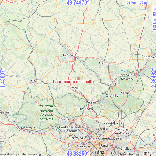
Laboissière-en-Thelle GPS coordinates[2]
49° 17' 35.844" North, 2° 9' 41.4" East
| Map corner | latitude | longitude |
|---|---|---|
| Upper-left | 49.74973°, | 1.45837° |
| Center: | 49.29329°, | 2.1615° |
| Lower-right: | 48.83259°, | 2.86462° |
| Map W x H: | 102×102 km | = 63.4×63.4mi |
| max Lat: | 51.07786° ⇑14.1% North |
| Laboissière-en-Thelle: | 49.29329° |
| min Lat: | ⇓85.9% South 41.3874° |
| min Long | Laboissière-en | max Long |
| -5.08615° | 2.1615° | 9.52242° |
| W 45%⇐ | ⇒55% E |
Elevation
Elevation of Laboissière-en-Thelle is 198 m = 650 ft, and this is 4.3 m = 14 ft above average elevation for this country.
| Max E: |
2333 m = 7654 ft | 34.2% |
| Laboissière-en-Thelle | 198 m 650 ft | |
| Avg. | 193.7 m = 635 ft | |
Min E: |
-1 m = -3 ft | 65.8% |
See also: France elevation on elevation.city.
Geographical zone
Laboissière-en-Thelle is located in North temperate zone (between Tropic of Cancer and the Arctic Circle). Distance of this North polar circle is 1920.3 km =1193.2 mi to North.| Distance of | km | miles | from Laboissière-en-Thelle |
|---|---|---|---|
| North Pole | 4526.2 | 2812.4 | to North |
| Arctic Circle | 1920.3 | 1193.2 | to North |
| Tropic Cancer | 2875 | 1786.4 | to South |
| Equator | 5480.9 | 3405.7 | to South |


Nearby cities:
15 places around Laboissière-en-Thelle: (largest is in red/bold)
• Andeville
3.6 km =2.2 mi,  176°
176°
• Auteuil
7.6 km =4.7 mi,  315°
315°
• Berthecourt
7.9 km =4.9 mi,  35°
35°
• Cauvigny
6.4 km =4 mi,  81°
81°
• Lachapelle-Saint-Pierre
6 km =3.7 mi,  116°
116°
• Le Coudray-sur-Thelle
3 km =1.9 mi,  296°
296°
• Lormaison
5.8 km =3.6 mi,  224°
224°
• Mortefontaine-en-Thelle
3.8 km =2.4 mi,  149°
149°
• Méru
7 km =4.3 mi,  197°
197°
• Noailles
4.8 km =3 mi, 35°
• Ponchon
6.4 km =4 mi,  23°
23°
• Saint-Crépin-Ibouvillers
6.9 km =4.3 mi,  240°
240°
• Saint-Sulpice
6.9 km =4.3 mi,  336°
336°
• Sainte-Geneviève
2.8 km =1.7 mi,  99°
99°
• Valdampierre
8 km =5 mi,  278°
278°
Sources, notices
• [Note1] Compared only with cities in France existing in our database
• [Src1] Map data: © OpenStreetMap contributors (CC-BY-SA)
• [Src2] Other city data from geonames.org with taken over terms of usage.
• [Src3] Geographical zone / Annual Mean Temperature by Robert A. Rohde @ Wikipedia
