Ponchon geodata
Ponchon (Hauts-de-France) is a populated place; located in France in Europe/Paris (GMT+2) time zone. With population of 1,085 people, there are 8226 cities with bigger population in this country. Compared to other cities in France, 86.9% of cities are located further ↓South; 54.5% of cities are located further →East and 64.4% of cities have higher elevation than Ponchon. Note1
Administrative division(s):
- Level 1: Hauts-de-France
- Level 2: Département de l'Oise
- Level 3: Arrondissement de Beauvais
- Level 4: Ponchon


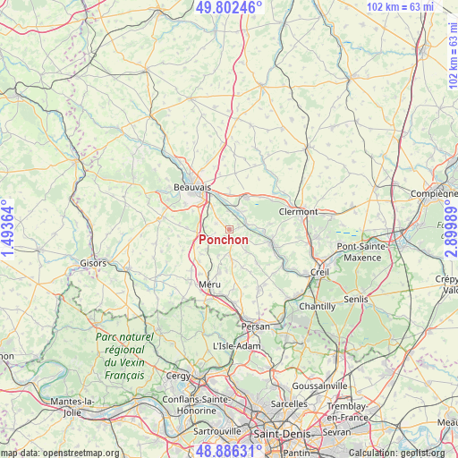
Ponchon GPS coordinates[2]
49° 20' 47.472" North, 2° 11' 48.372" East
| Map corner | latitude | longitude |
|---|---|---|
| Upper-left | 49.80246°, | 1.49364° |
| Center: | 49.34652°, | 2.19677° |
| Lower-right: | 48.88631°, | 2.89989° |
| Map W x H: | 101.9×101.9 km | = 63.3×63.3mi |
| max Lat: | 51.07786° ⇑13.1% North |
| Ponchon: | 49.34652° |
| min Lat: | ⇓86.9% South 41.3874° |
| min Long | Ponchon | max Long |
| -5.08615° | 2.19677° | 9.52242° |
| W 45.5%⇐ | ⇒54.5% E |
Elevation
Elevation of Ponchon is 91 m = 299 ft, and this is 102.7 m = 337 ft below average elevation for this country.
| Max E: |
2333 m = 7654 ft | 64.4% |
| Avg. | 193.7 m = 635 ft | |
| Ponchon | 91 m = 299 ft | |
Min E: |
-1 m = -3 ft | 35.6% |
See also: France elevation on elevation.city.
Geographical zone
Ponchon is located in North temperate zone (between Tropic of Cancer and the Arctic Circle). Distance of this North polar circle is 1914.4 km =1189.6 mi to North.| Distance of | km | miles | from Ponchon |
|---|---|---|---|
| North Pole | 4520.2 | 2808.7 | to North |
| Arctic Circle | 1914.4 | 1189.6 | to North |
| Tropic Cancer | 2880.9 | 1790.1 | to South |
| Equator | 5486.8 | 3409.3 | to South |


Nearby cities:
15 places around Ponchon: (largest is in red/bold)
• Bailleul-sur-Thérain
4.7 km =2.9 mi,  23°
23°
• Berthecourt
2.1 km =1.3 mi,  76°
76°
• Cauvigny
6.2 km =3.9 mi,  143°
143°
• Heilles
5.2 km =3.2 mi,  104°
104°
• Hermes
3.8 km =2.4 mi,  66°
66°
• Hondainville
7.7 km =4.8 mi,  94°
94°
• Laboissière-en-Thelle
6.4 km =4 mi,  203°
203°
• Le Coudray-sur-Thelle
6.9 km =4.3 mi,  228°
228°
• Noailles
2 km =1.2 mi,  172°
172°
• Rochy-Condé
6.2 km =3.9 mi,  351°
351°
• Saint-Félix
6.4 km =4 mi, 78°
• Saint-Sulpice
5.4 km =3.4 mi,  274°
274°
• Sainte-Geneviève
6.4 km =4 mi,  178°
178°
• Villers-Saint-Sépulcre
2.6 km =1.6 mi,  32°
32°
• Warluis
6.1 km =3.8 mi,  319°
319°
Sources, notices
• [Note1] Compared only with cities in France existing in our database
• [Src1] Map data: © OpenStreetMap contributors (CC-BY-SA)
• [Src2] Other city data from geonames.org with taken over terms of usage.
• [Src3] Geographical zone / Annual Mean Temperature by Robert A. Rohde @ Wikipedia
