Aburi geodata
Aburi (Eastern) is a populated place; located in Ghana in Africa/Accra (GMT+0) time zone. With population of 18,399 people, there are 57 cities with bigger population in this country. Compared to other cities in Ghana, 62.5% of cities are located further ↑North; 80.6% of cities are located further ←West and 95.8% of cities have lower elevation than Aburi. Note1


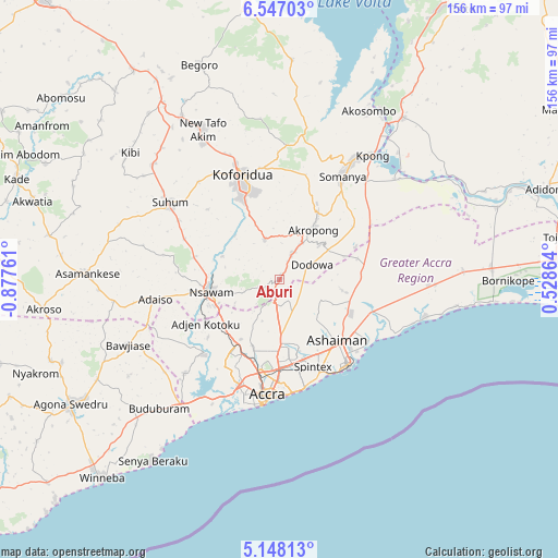
Aburi GPS coordinates[2]
5° 50' 52.872" North, 0° 10' 28.164" West
| Map corner | latitude | longitude |
|---|---|---|
| Upper-left | 6.54703°, | -0.87761° |
| Center: | 5.84802°, | -0.17449° |
| Lower-right: | 5.14813°, | 0.52864° |
| Map W x H: | 155.5×155.5 km | = 96.6×96.6mi |
| max Lat: | 11.0616° ⇑62.5% North |
| Aburi: | 5.84802° |
| min Lat: | ⇓37.5% South 4.86641° |
| min Long | Aburi | max Long |
| -2.78516° | -0.17449° | 1.19012° |
| W 80.6%⇐ | ⇒19.4% E |
Elevation
Elevation of Aburi is 447 m = 1467 ft, and this is 276.8 m = 908 ft above average elevation for this country.
| Max E: |
477 m = 1565 ft | 4.2% |
| Aburi | 447 m 1467 ft | |
| Avg. | 170.2 m = 558 ft | |
Min E: |
0 m = 0 ft | 95.8% |
See also: Ghana elevation on elevation.city.
Geographical zone
Aburi is located in North Torrid zone (between Equator and Tropic of Cancer). Distance of Equator is 650.2 km =404 mi to South.| Distance of | km | miles | from Aburi |
|---|---|---|---|
| North Pole | 9356.8 | 5814 | to North |
| Arctic Circle | 6750.9 | 4194.8 | to North |
| Tropic Cancer | 1955.7 | 1215.2 | to North |
| Equator | 650.2 | 404 | to South |


Nearby cities:
15 places around Aburi: (largest is in red/bold)
• Accra
32.6 km =20.3 mi,  184°
184°
• Akropong
17.2 km =10.7 mi,  34°
34°
• Asamankese
54.1 km =33.6 mi,  271°
271°
• Atsiaman
23.8 km =14.8 mi,  225°
225°
• Dome
23 km =14.3 mi,  197°
197°
• Gbawe
33.7 km =20.9 mi,  206°
206°
• Kasoa
44 km =27.3 mi,  217°
217°
• Kibi
54.8 km =34.1 mi,  310°
310°
• Koforidua
28.9 km =18 mi,  341°
341°
• Medina Estates
20.3 km =12.6 mi, 176°
• Nsawam
19.9 km =12.4 mi,  257°
257°
• Nungua
29.5 km =18.3 mi,  158°
158°
• Suhum
37.3 km =23.2 mi, 305°
• Tema
26.4 km =16.4 mi,  138°
138°
• Teshi Old Town
30.3 km =18.8 mi,  165°
165°
Sources, notices
• [Note1] Compared only with cities in Ghana existing in our database
• [Src1] Map data: © OpenStreetMap contributors (CC-BY-SA)
• [Src2] Other city data from geonames.org with taken over terms of usage.
• [Src3] Geographical zone / Annual Mean Temperature by Robert A. Rohde @ Wikipedia
