Tema geodata
Tema (Greater Accra) is a populated place; located in Ghana in Africa/Accra (GMT+0) time zone. With population of 155,782 people, there are 5 cities with bigger population in this country. Compared to other cities in Ghana, 70.8% of cities are located further ↑North; 88.9% of cities are located further ←West and 83.3% of cities have higher elevation than Tema. Note1


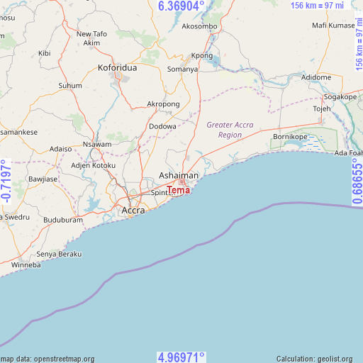
Tema GPS coordinates[2]
5° 40' 11.28" North, 0° 0' 59.652" West
| Map corner | latitude | longitude |
|---|---|---|
| Upper-left | 6.36904°, | -0.7197° |
| Center: | 5.6698°, | -0.01657° |
| Lower-right: | 4.96971°, | 0.68655° |
| Map W x H: | 155.6×155.6 km | = 96.7×96.7mi |
| max Lat: | 11.0616° ⇑70.8% North |
| Tema: | 5.6698° |
| min Lat: | ⇓29.2% South 4.86641° |
| min Long | Tema | max Long |
| -2.78516° | -0.01657° | 1.19012° |
| W 88.9%⇐ | ⇒11.1% E |
Elevation
Elevation of Tema is 27 m = 89 ft, and this is 143.2 m = 470 ft below average elevation for this country.
| Max E: |
477 m = 1565 ft | 83.3% |
| Avg. | 170.2 m = 558 ft | |
| Tema | 27 m = 89 ft | |
Min E: |
0 m = 0 ft | 16.7% |
See also: Tema elevation on elevation.city.
Geographical zone
Tema is located in North Torrid zone (between Equator and Tropic of Cancer). Distance of Equator is 630.4 km =391.7 mi to South.| Distance of | km | miles | from Tema |
|---|---|---|---|
| North Pole | 9376.6 | 5826.3 | to North |
| Arctic Circle | 6770.8 | 4207.2 | to North |
| Tropic Cancer | 1975.5 | 1227.5 | to North |
| Equator | 630.4 | 391.7 | to South |


Nearby cities:
15 places around Tema: (largest is in red/bold)
• Aburi
26.4 km =16.4 mi,  318°
318°
• Accra
23.6 km =14.7 mi,  237°
237°
• Akropong
34.7 km =21.6 mi,  347°
347°
• Asamankese
74.6 km =46.4 mi,  286°
286°
• Atsiaman
34.6 km =21.5 mi,  275°
275°
• Dome
24.4 km =15.2 mi,  264°
264°
• Gbawe
34.1 km =21.2 mi,  252°
252°
• Kasoa
46.8 km =29.1 mi, 251°
• Koforidua
54.3 km =33.7 mi,  330°
330°
• Medina Estates
16.2 km =10.1 mi,  268°
268°
• Nsawam
40 km =24.9 mi, 292°
• Nungua
10.2 km =6.3 mi,  221°
221°
• Suhum
63.3 km =39.3 mi,  310°
310°
• Teshi Old Town
13.9 km =8.6 mi,  226°
226°
• Winneba
75.9 km =47.2 mi, 242°
Sources, notices
• [Note1] Compared only with cities in Ghana existing in our database
• [Src1] Map data: © OpenStreetMap contributors (CC-BY-SA)
• [Src2] Other city data from geonames.org with taken over terms of usage.
• [Src3] Geographical zone / Annual Mean Temperature by Robert A. Rohde @ Wikipedia
