Koforidua geodata
Koforidua (Eastern) is a seat of a first-order administrative division; located in Ghana in Africa/Accra (GMT+0) time zone. With population of 96,266 people, there are 11 cities with bigger population in this country. Compared to other cities in Ghana, 50% of cities are located further ↓South; 75% of cities are located further ←West and 54.2% of cities have lower elevation than Koforidua. Note1


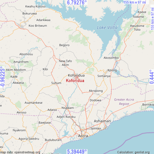
Koforidua GPS coordinates[2]
6° 5' 38.688" North, 0° 15' 32.868" West
| Map corner | latitude | longitude |
|---|---|---|
| Upper-left | 6.79276°, | -0.96225° |
| Center: | 6.09408°, | -0.25913° |
| Lower-right: | 5.39449°, | 0.444° |
| Map W x H: | 155.5×155.5 km | = 96.6×96.6mi |
| max Lat: | 11.0616° ⇑50% North |
| Koforidua: | 6.09408° |
| min Lat: | ⇓50% South 4.86641° |
| min Long | Koforidua | max Long |
| -2.78516° | -0.25913° | 1.19012° |
| W 75%⇐ | ⇒25% E |
Elevation
Elevation of Koforidua is 172 m = 564 ft, and this is 1.8 m = 6 ft above average elevation for this country.
| Max E: |
477 m = 1565 ft | 45.8% |
| Koforidua | 172 m 564 ft | |
| Avg. | 170.2 m = 558 ft | |
Min E: |
0 m = 0 ft | 54.2% |
See also: Koforidua elevation on elevation.city.
Geographical zone
Koforidua is located in North Torrid zone (between Equator and Tropic of Cancer). Distance of Equator is 677.6 km =421 mi to South.| Distance of | km | miles | from Koforidua |
|---|---|---|---|
| North Pole | 9329.5 | 5797.1 | to North |
| Arctic Circle | 6723.6 | 4177.9 | to North |
| Tropic Cancer | 1928.3 | 1198.2 | to North |
| Equator | 677.6 | 421 | to South |


Nearby cities:
15 places around Koforidua: (largest is in red/bold)
• Aburi
28.9 km =18 mi,  161°
161°
• Accra
60.2 km =37.4 mi,  173°
173°
• Akropong
23.4 km =14.5 mi,  124°
124°
• Asamankese
51.7 km =32.1 mi,  239°
239°
• Atsiaman
44.7 km =27.8 mi,  189°
189°
• Begoro
35.1 km =21.8 mi,  338°
338°
• Dome
49.4 km =30.7 mi,  177°
177°
• Gbawe
57.8 km =35.9 mi, 185°
• Kibi
33.5 km =20.8 mi,  283°
283°
• Medina Estates
48.8 km =30.3 mi, 167°
• Nsawam
33.3 km =20.7 mi,  197°
197°
• Nungua
58.4 km =36.3 mi, 159°
• Suhum
21.9 km =13.6 mi,  254°
254°
• Tema
54.3 km =33.7 mi,  150°
150°
• Teshi Old Town
59.2 km =36.8 mi, 163°
Sources, notices
• [Note1] Compared only with cities in Ghana existing in our database
• [Src1] Map data: © OpenStreetMap contributors (CC-BY-SA)
• [Src2] Other city data from geonames.org with taken over terms of usage.
• [Src3] Geographical zone / Annual Mean Temperature by Robert A. Rohde @ Wikipedia
