Asamankese geodata
Asamankese (Eastern) is a populated place; located in Ghana in Africa/Accra (GMT+0) time zone. With population of 39,435 people, there are 37 cities with bigger population in this country. Compared to other cities in Ghana, 61.1% of cities are located further ↑North; 61.1% of cities are located further ←West and 54.2% of cities have higher elevation than Asamankese. Note1


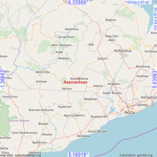
Asamankese GPS coordinates[2]
5° 51' 36.216" North, 0° 39' 48.6" West
| Map corner | latitude | longitude |
|---|---|---|
| Upper-left | 6.55906°, | -1.36663° |
| Center: | 5.86006°, | -0.6635° |
| Lower-right: | 5.16019°, | 0.03963° |
| Map W x H: | 155.5×155.5 km | = 96.6×96.6mi |
| max Lat: | 11.0616° ⇑61.1% North |
| Asamankese: | 5.86006° |
| min Lat: | ⇓38.9% South 4.86641° |
| min Long | Asamankese | max Long |
| -2.78516° | -0.6635° | 1.19012° |
| W 61.1%⇐ | ⇒38.9% E |
Elevation
Elevation of Asamankese is 147 m = 482 ft, and this is 23.2 m = 76 ft below average elevation for this country.
| Max E: |
477 m = 1565 ft | 54.2% |
| Avg. | 170.2 m = 558 ft | |
| Asamankese | 147 m = 482 ft | |
Min E: |
0 m = 0 ft | 45.8% |
See also: Ghana elevation on elevation.city.
Geographical zone
Asamankese is located in North Torrid zone (between Equator and Tropic of Cancer). Distance of Equator is 651.6 km =404.9 mi to South.| Distance of | km | miles | from Asamankese |
|---|---|---|---|
| North Pole | 9355.5 | 5813.2 | to North |
| Arctic Circle | 6749.6 | 4194 | to North |
| Tropic Cancer | 1954.3 | 1214.3 | to North |
| Equator | 651.6 | 404.9 | to South |


Nearby cities:
15 places around Asamankese: (largest is in red/bold)
• Aburi
54.1 km =33.6 mi,  91°
91°
• Akim Oda
36.4 km =22.6 mi,  281°
281°
• Akim Swedru
39.2 km =24.4 mi, 275°
• Akwatia
25.7 km =16 mi,  321°
321°
• Atsiaman
41.2 km =25.6 mi,  115°
115°
• Dome
52.7 km =32.7 mi, 116°
• Gbawe
50.2 km =31.2 mi,  128°
128°
• Kasoa
45.3 km =28.1 mi,  142°
142°
• Kibi
36 km =22.4 mi,  19°
19°
• Koforidua
51.7 km =32.1 mi,  59°
59°
• Medina Estates
59.4 km =36.9 mi,  111°
111°
• Nsawam
35.1 km =21.8 mi,  99°
99°
• Suhum
31 km =19.3 mi,  49°
49°
• Swedru
36.1 km =22.4 mi,  186°
186°
• Winneba
56.8 km =35.3 mi,  175°
175°
Sources, notices
• [Note1] Compared only with cities in Ghana existing in our database
• [Src1] Map data: © OpenStreetMap contributors (CC-BY-SA)
• [Src2] Other city data from geonames.org with taken over terms of usage.
• [Src3] Geographical zone / Annual Mean Temperature by Robert A. Rohde @ Wikipedia
