Atsiaman geodata
Atsiaman (Greater Accra) is a populated place; located in Ghana in Africa/Accra (GMT+0) time zone. With population of 202,932 people, there are 4 cities with bigger population in this country. Compared to other cities in Ghana, 69.4% of cities are located further ↑North; 72.2% of cities are located further ←West and 75% of cities have higher elevation than Atsiaman. Note1


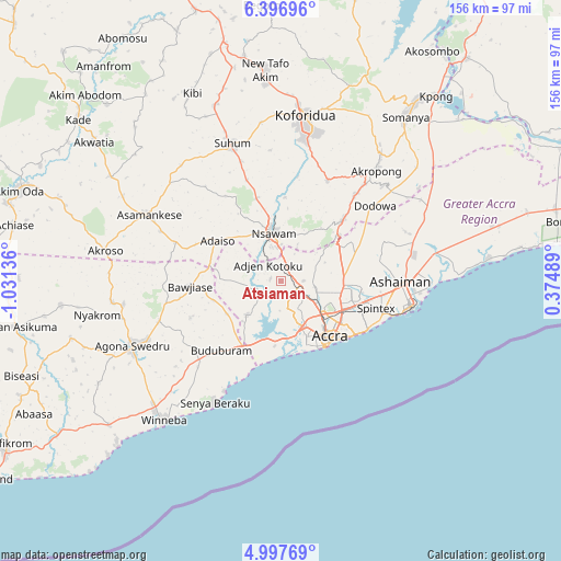
Atsiaman GPS coordinates[2]
5° 41' 51.9" North, 0° 19' 41.664" West
| Map corner | latitude | longitude |
|---|---|---|
| Upper-left | 6.39696°, | -1.03136° |
| Center: | 5.69775°, | -0.32824° |
| Lower-right: | 4.99769°, | 0.37489° |
| Map W x H: | 155.6×155.6 km | = 96.7×96.7mi |
| max Lat: | 11.0616° ⇑69.4% North |
| Atsiaman: | 5.69775° |
| min Lat: | ⇓30.6% South 4.86641° |
| min Long | Atsiaman | max Long |
| -2.78516° | -0.32824° | 1.19012° |
| W 72.2%⇐ | ⇒27.8% E |
Elevation
Elevation of Atsiaman is 45 m = 148 ft, and this is 125.2 m = 411 ft below average elevation for this country.
| Max E: |
477 m = 1565 ft | 75% |
| Avg. | 170.2 m = 558 ft | |
| Atsiaman | 45 m = 148 ft | |
Min E: |
0 m = 0 ft | 25% |
See also: Atsiaman elevation on elevation.city.
Geographical zone
Atsiaman is located in North Torrid zone (between Equator and Tropic of Cancer). Distance of Equator is 633.5 km =393.6 mi to South.| Distance of | km | miles | from Atsiaman |
|---|---|---|---|
| North Pole | 9373.5 | 5824.4 | to North |
| Arctic Circle | 6767.6 | 4205.2 | to North |
| Tropic Cancer | 1972.4 | 1225.6 | to North |
| Equator | 633.5 | 393.6 | to South |


Nearby cities:
15 places around Atsiaman: (largest is in red/bold)
• Aburi
23.8 km =14.8 mi,  45°
45°
• Accra
21.4 km =13.3 mi,  137°
137°
• Akropong
40.9 km =25.4 mi,  41°
41°
• Asamankese
41.2 km =25.6 mi,  295°
295°
• Dome
11.5 km =7.1 mi,  117°
117°
• Gbawe
13.6 km =8.5 mi,  171°
171°
• Kasoa
20.6 km =12.8 mi,  208°
208°
• Koforidua
44.7 km =27.8 mi,  9°
9°
• Medina Estates
18.6 km =11.6 mi,  101°
101°
• Nsawam
12.6 km =7.8 mi,  348°
348°
• Nungua
29.8 km =18.5 mi,  111°
111°
• Suhum
40.5 km =25.2 mi,  340°
340°
• Swedru
44.8 km =27.8 mi,  246°
246°
• Tema
34.6 km =21.5 mi, 95°
• Teshi Old Town
27.6 km =17.1 mi, 117°
Sources, notices
• [Note1] Compared only with cities in Ghana existing in our database
• [Src1] Map data: © OpenStreetMap contributors (CC-BY-SA)
• [Src2] Other city data from geonames.org with taken over terms of usage.
• [Src3] Geographical zone / Annual Mean Temperature by Robert A. Rohde @ Wikipedia
