Accra geodata
Accra (Greater Accra) is a capital of a political entity; located in Ghana in Africa/Accra (GMT+0) time zone. With population of 1,963,264 people, there are 0 cities with bigger population in this country. Compared to other cities in Ghana, 79.2% of cities are located further ↑North; 79.2% of cities are located further ←West and 79.2% of cities have higher elevation than Accra. Note1


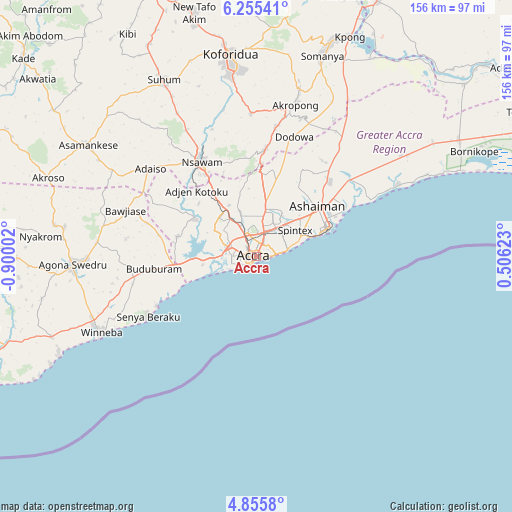
Accra GPS coordinates[2]
5° 33' 21.672" North, 0° 11' 48.84" West
| Map corner | latitude | longitude |
|---|---|---|
| Upper-left | 6.25541°, | -0.90002° |
| Center: | 5.55602°, | -0.1969° |
| Lower-right: | 4.8558°, | 0.50623° |
| Map W x H: | 155.6×155.6 km | = 96.7×96.7mi |
| max Lat: | 11.0616° ⇑79.2% North |
| Accra: | 5.55602° |
| min Lat: | ⇓20.8% South 4.86641° |
| min Long | Accra | max Long |
| -2.78516° | -0.1969° | 1.19012° |
| W 79.2%⇐ | ⇒20.8% E |
Elevation
Elevation of Accra is 33 m = 108 ft, and this is 137.2 m = 450 ft below average elevation for this country.
| Max E: |
477 m = 1565 ft | 79.2% |
| Avg. | 170.2 m = 558 ft | |
| Accra | 33 m = 108 ft | |
Min E: |
0 m = 0 ft | 20.8% |
See also: Accra elevation on elevation.city.
Geographical zone
Accra is located in North Torrid zone (between Equator and Tropic of Cancer). Distance of Equator is 617.8 km =383.9 mi to South.| Distance of | km | miles | from Accra |
|---|---|---|---|
| North Pole | 9389.3 | 5834.2 | to North |
| Arctic Circle | 6783.4 | 4215 | to North |
| Tropic Cancer | 1988.1 | 1235.3 | to North |
| Equator | 617.8 | 383.9 | to South |


Nearby cities:
15 places around Accra: (largest is in red/bold)
• Aburi
32.6 km =20.3 mi,  4°
4°
• Akropong
48.2 km =30 mi,  14°
14°
• Atsiaman
21.4 km =13.3 mi,  317°
317°
• Dome
11.3 km =7 mi,  337°
337°
• Gbawe
12.8 km =8 mi,  280°
280°
• Kasoa
24.5 km =15.2 mi,  264°
264°
• Koforidua
60.2 km =37.4 mi,  353°
353°
• Medina Estates
12.8 km =8 mi,  17°
17°
• Nsawam
32.8 km =20.4 mi,  328°
328°
• Nungua
14.2 km =8.8 mi,  69°
69°
• Suhum
60.8 km =37.8 mi, 332°
• Swedru
55.7 km =34.6 mi,  267°
267°
• Tema
23.6 km =14.7 mi,  57°
57°
• Teshi Old Town
10.4 km =6.5 mi, 72°
• Winneba
52.4 km =32.6 mi,  244°
244°
Sources, notices
• [Note1] Compared only with cities in Ghana existing in our database
• [Src1] Map data: © OpenStreetMap contributors (CC-BY-SA)
• [Src2] Other city data from geonames.org with taken over terms of usage.
• [Src3] Geographical zone / Annual Mean Temperature by Robert A. Rohde @ Wikipedia
