Medina Estates geodata
Medina Estates (Greater Accra) is a populated place; located in Ghana in Africa/Accra (GMT+0) time zone. With population of 101,207 people, there are 10 cities with bigger population in this country. Compared to other cities in Ghana, 72.2% of cities are located further ↑North; 81.9% of cities are located further ←West and 63.9% of cities have higher elevation than Medina Estates. Note1


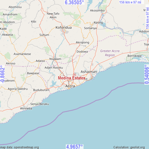
Medina Estates GPS coordinates[2]
5° 39' 56.88" North, 0° 9' 47.052" West
| Map corner | latitude | longitude |
|---|---|---|
| Upper-left | 6.36505°, | -0.8662° |
| Center: | 5.6658°, | -0.16307° |
| Lower-right: | 4.9657°, | 0.54006° |
| Map W x H: | 155.6×155.6 km | = 96.7×96.7mi |
| max Lat: | 11.0616° ⇑72.2% North |
| Medina Estates: | 5.6658° |
| min Lat: | ⇓27.8% South 4.86641° |
| min Long | Medina Estates | max Long |
| -2.78516° | -0.16307° | 1.19012° |
| W 81.9%⇐ | ⇒18.1% E |
Elevation
Elevation of Medina Estates is 86 m = 282 ft, and this is 84.2 m = 276 ft below average elevation for this country.
| Max E: |
477 m = 1565 ft | 63.9% |
| Avg. | 170.2 m = 558 ft | |
| Medina Estates | 86 m = 282 ft | |
Min E: |
0 m = 0 ft | 36.1% |
See also: Medina Estates elevation on elevation.city.
Geographical zone
Medina Estates is located in North Torrid zone (between Equator and Tropic of Cancer). Distance of Equator is 630 km =391.5 mi to South.| Distance of | km | miles | from Medina Estates |
|---|---|---|---|
| North Pole | 9377.1 | 5826.7 | to North |
| Arctic Circle | 6771.2 | 4207.4 | to North |
| Tropic Cancer | 1975.9 | 1227.8 | to North |
| Equator | 630 | 391.5 | to South |


Nearby cities:
15 places around Medina Estates: (largest is in red/bold)
• Aburi
20.3 km =12.6 mi,  356°
356°
• Accra
12.8 km =8 mi,  197°
197°
• Akropong
35.4 km =22 mi,  14°
14°
• Asamankese
59.4 km =36.9 mi,  291°
291°
• Atsiaman
18.6 km =11.6 mi,  281°
281°
• Dome
8.3 km =5.2 mi,  257°
257°
• Gbawe
19.1 km =11.9 mi,  238°
238°
• Kasoa
31.6 km =19.6 mi, 242°
• Koforidua
48.8 km =30.3 mi,  347°
347°
• Nsawam
26.1 km =16.2 mi,  307°
307°
• Nungua
11.9 km =7.4 mi,  127°
127°
• Suhum
52.4 km =32.6 mi,  322°
322°
• Swedru
61.1 km =38 mi, 256°
• Tema
16.2 km =10.1 mi,  88°
88°
• Teshi Old Town
11 km =6.8 mi,  145°
145°
Sources, notices
• [Note1] Compared only with cities in Ghana existing in our database
• [Src1] Map data: © OpenStreetMap contributors (CC-BY-SA)
• [Src2] Other city data from geonames.org with taken over terms of usage.
• [Src3] Geographical zone / Annual Mean Temperature by Robert A. Rohde @ Wikipedia
