Dome geodata
Dome (Greater Accra) is a populated place; located in Ghana in Africa/Accra (GMT+0) time zone. With population of 47,260 people, there are 28 cities with bigger population in this country. Compared to other cities in Ghana, 73.6% of cities are located further ↑North; 77.8% of cities are located further ←West and 76.4% of cities have higher elevation than Dome. Note1


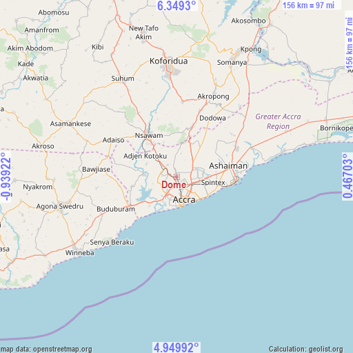
Dome GPS coordinates[2]
5° 39' 0.108" North, 0° 14' 9.96" West
| Map corner | latitude | longitude |
|---|---|---|
| Upper-left | 6.3493°, | -0.93922° |
| Center: | 5.65003°, | -0.2361° |
| Lower-right: | 4.94992°, | 0.46703° |
| Map W x H: | 155.6×155.6 km | = 96.7×96.7mi |
| max Lat: | 11.0616° ⇑73.6% North |
| Dome: | 5.65003° |
| min Lat: | ⇓26.4% South 4.86641° |
| min Long | Dome | max Long |
| -2.78516° | -0.2361° | 1.19012° |
| W 77.8%⇐ | ⇒22.2% E |
Elevation
Elevation of Dome is 35 m = 115 ft, and this is 135.2 m = 444 ft below average elevation for this country.
| Max E: |
477 m = 1565 ft | 76.4% |
| Avg. | 170.2 m = 558 ft | |
| Dome | 35 m = 115 ft | |
Min E: |
0 m = 0 ft | 23.6% |
See also: Dome elevation on elevation.city.
Geographical zone
Dome is located in North Torrid zone (between Equator and Tropic of Cancer). Distance of Equator is 628.2 km =390.3 mi to South.| Distance of | km | miles | from Dome |
|---|---|---|---|
| North Pole | 9378.8 | 5827.7 | to North |
| Arctic Circle | 6772.9 | 4208.5 | to North |
| Tropic Cancer | 1977.7 | 1228.9 | to North |
| Equator | 628.2 | 390.3 | to South |


Nearby cities:
15 places around Dome: (largest is in red/bold)
• Aburi
23 km =14.3 mi,  17°
17°
• Accra
11.3 km =7 mi,  157°
157°
• Akropong
39.8 km =24.7 mi, 24°
• Asamankese
52.7 km =32.7 mi,  296°
296°
• Atsiaman
11.5 km =7.1 mi, 297°
• Gbawe
11.6 km =7.2 mi,  225°
225°
• Kasoa
23.8 km =14.8 mi,  237°
237°
• Koforidua
49.4 km =30.7 mi,  357°
357°
• Medina Estates
8.3 km =5.2 mi,  77°
77°
• Nsawam
21.7 km =13.5 mi,  324°
324°
• Nungua
18.4 km =11.4 mi,  107°
107°
• Suhum
49.5 km =30.8 mi,  331°
331°
• Swedru
52.8 km =32.8 mi,  256°
256°
• Tema
24.4 km =15.2 mi, 84°
• Teshi Old Town
16.1 km =10 mi,  117°
117°
Sources, notices
• [Note1] Compared only with cities in Ghana existing in our database
• [Src1] Map data: © OpenStreetMap contributors (CC-BY-SA)
• [Src2] Other city data from geonames.org with taken over terms of usage.
• [Src3] Geographical zone / Annual Mean Temperature by Robert A. Rohde @ Wikipedia
