San Vicente Pacaya geodata
San Vicente Pacaya (Escuintla) is a seat of a second-order administrative division; located in Guatemala in America/Guatemala (GMT-6) time zone. With population of 7,162 people, there are 170 cities with bigger population in this country. Compared to other cities in Guatemala, 87.6% of cities are located further ↑North; 62.8% of cities are located further ←West and 62.2% of cities have lower elevation than San Vicente Pacaya. Note1


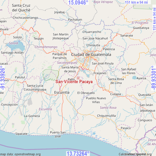
San Vicente Pacaya GPS coordinates[2]
14° 24' 52.776" North, 90° 38' 10.068" West
| Map corner | latitude | longitude |
|---|---|---|
| Upper-left | 15.0946°, | -91.33926° |
| Center: | 14.41466°, | -90.63613° |
| Lower-right: | 13.73264°, | -89.93301° |
| Map W x H: | 151.4×151.4 km | = 94.1×94.1mi |
| max Lat: | 17.06606° ⇑87.6% North |
| San Vicente Pacaya: | 14.41466° |
| min Lat: | ⇓12.4% South 13.9274° |
| min Long | San Vicente Pac | max Long |
| -92.19298° | -90.63613° | -88.59444° |
| W 62.8%⇐ | ⇒37.2% E |
Elevation
Elevation of San Vicente Pacaya is 1582 m = 5190 ft, and this is 315 m = 1033 ft above average elevation for this country.
| Max E: |
3254 m = 10676 ft | 37.8% |
| San Vicente Pacaya | 1582 m 5190 ft | |
| Avg. | 1267 m = 4157 ft | |
Min E: |
1 m = 3 ft | 62.2% |
See also: Guatemala elevation on elevation.city.
Geographical zone
San Vicente Pacaya is located in North Torrid zone (between Equator and Tropic of Cancer). Distance of this Northern Tropic circle is 1003.2 km =623.4 mi to North.| Distance of | km | miles | from San Vicente Pacaya |
|---|---|---|---|
| North Pole | 8404.3 | 5222.2 | to North |
| Arctic Circle | 5798.4 | 3603 | to North |
| Tropic Cancer | 1003.2 | 623.4 | to North |
| Equator | 1602.8 | 995.9 | to South |


Nearby cities:
15 places around San Vicente Pacaya: (largest is in red/bold)
• Alotenango
19.8 km =12.3 mi,  291°
291°
• Amatitlán
7 km =4.3 mi,  1°
1°
• Antigua Guatemala
19.4 km =12.1 mi,  326°
326°
• Ciudad Vieja
18.3 km =11.4 mi,  311°
311°
• Escuintla
20.1 km =12.5 mi,  232°
232°
• Guanagazapa
21.1 km =13.1 mi,  182°
182°
• Jocotenango
21.2 km =13.2 mi, 328°
• Magdalena Milpas Altas
15.4 km =9.6 mi,  344°
344°
• Palín
6.6 km =4.1 mi,  259°
259°
• Petapa
12.6 km =7.8 mi,  39°
39°
• San Miguel Dueñas
21.3 km =13.2 mi,  304°
304°
• Santa Lucía Milpas Altas
18.5 km =11.5 mi,  346°
346°
• Santa María de Jesús
11.9 km =7.4 mi,  318°
318°
• Villa Canales
13.3 km =8.3 mi,  55°
55°
• Villa Nueva
13.4 km =8.3 mi,  23°
23°
Sources, notices
• [Note1] Compared only with cities in Guatemala existing in our database
• [Src1] Map data: © OpenStreetMap contributors (CC-BY-SA)
• [Src2] Other city data from geonames.org with taken over terms of usage.
• [Src3] Geographical zone / Annual Mean Temperature by Robert A. Rohde @ Wikipedia
