Guatemala City geodata
Guatemala City (Guatemala) is a capital of a political entity; located in Guatemala in America/Guatemala (GMT-6) time zone. With population of 994,938 people, there are 0 cities with bigger population in this country. Compared to other cities in Guatemala, 65.8% of cities are located further ↑North; 66.1% of cities are located further ←West and 59% of cities have lower elevation than Guatemala City. Note1


Guatemala City GPS coordinates[2]
14° 38' 26.592" North, 90° 30' 47.772" West
| Map corner | latitude | longitude |
|---|---|---|
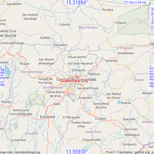
| Upper-left | 15.31994°, | -91.2164° |
| Center: | 14.64072°, | -90.51327° |
| Lower-right: | 13.95939°, | -89.81015° |
| Map W x H: | 151.3×151.3 km | = 94×94mi |
| max Lat: | 17.06606° ⇑65.8% North |
| Guatemala City: | 14.64072° |
| min Lat: | ⇓34.2% South 13.9274° |
| min Long | Guatemala City | max Long |
| -92.19298° | -90.51327° | -88.59444° |
| W 66.1%⇐ | ⇒33.9% E |
Elevation
Elevation of Guatemala City is 1508 m = 4948 ft, and this is 241 m = 791 ft above average elevation for this country.
| Max E: |
3254 m = 10676 ft | 41% |
| Guatemala City | 1508 m 4948 ft | |
| Avg. | 1267 m = 4157 ft | |
Min E: |
1 m = 3 ft | 59% |
See also: Guatemala City elevation on elevation.city.
Geographical zone
Guatemala City is located in North Torrid zone (between Equator and Tropic of Cancer). Distance of this Northern Tropic circle is 978 km =607.7 mi to North.| Distance of | km | miles | from Guatemala City |
|---|---|---|---|
| North Pole | 8379.2 | 5206.6 | to North |
| Arctic Circle | 5773.3 | 3587.4 | to North |
| Tropic Cancer | 978 | 607.7 | to North |
| Equator | 1627.9 | 1011.5 | to South |


Nearby cities:
15 places around Guatemala City: (largest is in red/bold)
• Chinautla
7.1 km =4.4 mi,  11°
11°
• Mixco
10.2 km =6.3 mi,  263°
263°
• Palencia
17 km =10.6 mi,  80°
80°
• Petapa
16.3 km =10.1 mi,  198°
198°
• San Bartolomé Milpas Altas
18.1 km =11.2 mi, 258°
• San José Pinula
15.1 km =9.4 mi,  134°
134°
• San Juan Sacatepéquez
16.5 km =10.3 mi,  301°
301°
• San Lucas Sacatepéquez
15.8 km =9.8 mi, 257°
• San Pedro Ayampuc
16.7 km =10.4 mi,  22°
22°
• San Pedro Sacatepéquez
14.8 km =9.2 mi,  289°
289°
• San Raimundo
16.3 km =10.1 mi,  327°
327°
• Santa Catarina Pinula
8 km =5 mi,  169°
169°
• Santiago Sacatepéquez
17.6 km =10.9 mi,  267°
267°
• Villa Canales
17.7 km =11 mi,  187°
187°
• Villa Nueva
15 km =9.3 mi,  211°
211°
In other languages:
- In Spanish: Ciudad de Guatemala
- In France: Guatemala
- In German: Guatemala-Stadt
- In Italian: Città del Guatemala
- In Russian: Гватемала
Sources, notices
• [Note1] Compared only with cities in Guatemala existing in our database
• [Src1] Map data: © OpenStreetMap contributors (CC-BY-SA)
• [Src2] Other city data from geonames.org with taken over terms of usage.
• [Src3] Geographical zone / Annual Mean Temperature by Robert A. Rohde @ Wikipedia
