Villa Canales geodata
Villa Canales (Guatemala) is a seat of a second-order administrative division; located in Guatemala in America/Guatemala (GMT-6) time zone. With population of 122,194 people, there are 6 cities with bigger population in this country. Compared to other cities in Guatemala, 84.1% of cities are located further ↑North; 65.2% of cities are located further ←West and 50.1% of cities have lower elevation than Villa Canales. Note1


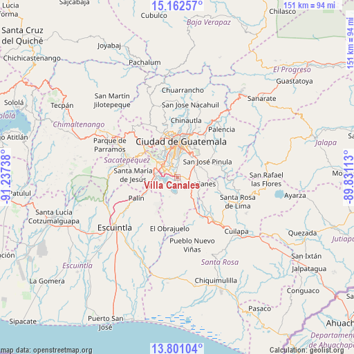
Villa Canales GPS coordinates[2]
14° 28' 58.26" North, 90° 32' 3.3" West
| Map corner | latitude | longitude |
|---|---|---|
| Upper-left | 15.16257°, | -91.23738° |
| Center: | 14.48285°, | -90.53425° |
| Lower-right: | 13.80104°, | -89.83113° |
| Map W x H: | 151.4×151.4 km | = 94.1×94.1mi |
| max Lat: | 17.06606° ⇑84.1% North |
| Villa Canales: | 14.48285° |
| min Lat: | ⇓15.9% South 13.9274° |
| min Long | Villa Canales | max Long |
| -92.19298° | -90.53425° | -88.59444° |
| W 65.2%⇐ | ⇒34.8% E |
Elevation
Elevation of Villa Canales is 1259 m = 4131 ft, and this is 8 m = 26 ft below average elevation for this country.
| Max E: |
3254 m = 10676 ft | 49.9% |
| Avg. | 1267 m = 4157 ft | |
| Villa Canales | 1259 m = 4131 ft | |
Min E: |
1 m = 3 ft | 50.1% |
See also: Villa Canales elevation on elevation.city.
Geographical zone
Villa Canales is located in North Torrid zone (between Equator and Tropic of Cancer). Distance of this Northern Tropic circle is 995.6 km =618.6 mi to North.| Distance of | km | miles | from Villa Canales |
|---|---|---|---|
| North Pole | 8396.7 | 5217.5 | to North |
| Arctic Circle | 5790.8 | 3598.2 | to North |
| Tropic Cancer | 995.6 | 618.6 | to North |
| Equator | 1610.3 | 1000.6 | to South |


Nearby cities:
15 places around Villa Canales: (largest is in red/bold)
• Amatitlán
10.9 km =6.8 mi,  266°
266°
• Fraijanes
10.2 km =6.3 mi,  100°
100°
• Guatemala City
17.7 km =11 mi,  7°
7°
• Magdalena Milpas Altas
16.8 km =10.4 mi,  295°
295°
• Mixco
18.2 km =11.3 mi,  334°
334°
• Palín
19.6 km =12.2 mi,  243°
243°
• Petapa
3.7 km =2.3 mi,  305°
305°
• San José Pinula
14.8 km =9.2 mi,  61°
61°
• San Lucas Sacatepéquez
19.4 km =12.1 mi,  317°
317°
• San Vicente Pacaya
13.3 km =8.3 mi, 235°
• Santa Catarina Pinula
10.4 km =6.5 mi,  21°
21°
• Santa Cruz Naranjo
20.6 km =12.8 mi,  120°
120°
• Santa Lucía Milpas Altas
18.5 km =11.5 mi, 304°
• Santa María de Jesús
19 km =11.8 mi, 273°
• Villa Nueva
7.2 km =4.5 mi, 310°
Sources, notices
• [Note1] Compared only with cities in Guatemala existing in our database
• [Src1] Map data: © OpenStreetMap contributors (CC-BY-SA)
• [Src2] Other city data from geonames.org with taken over terms of usage.
• [Src3] Geographical zone / Annual Mean Temperature by Robert A. Rohde @ Wikipedia
