Sayaxché geodata
Sayaxché (Petén) is a seat of a second-order administrative division; located in Guatemala in America/Guatemala (GMT-6) time zone. With population of 9,100 people, there are 139 cities with bigger population in this country. Compared to other cities in Guatemala, 97.3% of cities are located further ↓South; 76.7% of cities are located further ←West and 93.5% of cities have higher elevation than Sayaxché. Note1


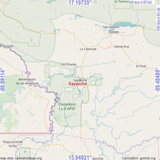
Sayaxché GPS coordinates[2]
16° 31' 28.056" North, 90° 11' 16.836" West
| Map corner | latitude | longitude |
|---|---|---|
| Upper-left | 17.19735°, | -90.89114° |
| Center: | 16.52446°, | -90.18801° |
| Lower-right: | 15.84921°, | -89.48489° |
| Map W x H: | 149.9×149.9 km | = 93.1×93.1mi |
| max Lat: | 17.06606° ⇑2.7% North |
| Sayaxché: | 16.52446° |
| min Lat: | ⇓97.3% South 13.9274° |
| min Long | Sayaxché | max Long |
| -92.19298° | -90.18801° | -88.59444° |
| W 76.7%⇐ | ⇒23.3% E |
Elevation
Elevation of Sayaxché is 134 m = 440 ft, and this is 1133 m = 3717 ft below average elevation for this country.
| Max E: |
3254 m = 10676 ft | 93.5% |
| Avg. | 1267 m = 4157 ft | |
| Sayaxché | 134 m = 440 ft | |
Min E: |
1 m = 3 ft | 6.5% |
See also: Guatemala elevation on elevation.city.
Geographical zone
Sayaxché is located in North Torrid zone (between Equator and Tropic of Cancer). Distance of this Northern Tropic circle is 768.6 km =477.6 mi to North.| Distance of | km | miles | from Sayaxché |
|---|---|---|---|
| North Pole | 8169.7 | 5076.4 | to North |
| Arctic Circle | 5563.8 | 3457.2 | to North |
| Tropic Cancer | 768.6 | 477.6 | to North |
| Equator | 1837.3 | 1141.6 | to South |


Nearby cities:
15 places around Sayaxché: (largest is in red/bold)
• Chisec
79.4 km =49.3 mi,  187°
187°
• Dolores
82.2 km =51.1 mi,  90°
90°
• El Chal
58.5 km =36.4 mi,  77°
77°
• Flores
53.9 km =33.5 mi,  34°
34°
• Fray Bartolomé de Las Casas
85.1 km =52.9 mi,  157°
157°
• La Libertad
30.3 km =18.8 mi,  14°
14°
• Playa Grande
87.8 km =54.6 mi,  221°
221°
• Poptún
85 km =52.8 mi,  104°
104°
• Raxruhá
75 km =46.6 mi,  167°
167°
• San Andrés
57 km =35.4 mi, 30°
• San Benito
52.2 km =32.4 mi, 33°
• San Francisco
40.9 km =25.4 mi,  41°
41°
• San José
59.5 km =37 mi, 31°
• San Luis
87.6 km =54.4 mi,  114°
114°
• Santa Ana
48.6 km =30.2 mi,  50°
50°
Sources, notices
• [Note1] Compared only with cities in Guatemala existing in our database
• [Src1] Map data: © OpenStreetMap contributors (CC-BY-SA)
• [Src2] Other city data from geonames.org with taken over terms of usage.
• [Src3] Geographical zone / Annual Mean Temperature by Robert A. Rohde @ Wikipedia
