Playa Grande geodata
Playa Grande (Quiché) is a seat of a second-order administrative division; located in Guatemala in America/Guatemala (GMT-6) time zone. In our database, there are 325 cities with bigger population. Compared to other cities in Guatemala, 96.2% of cities are located further ↓South; 58.7% of cities are located further ←West and 90% of cities have higher elevation than Playa Grande. Note1


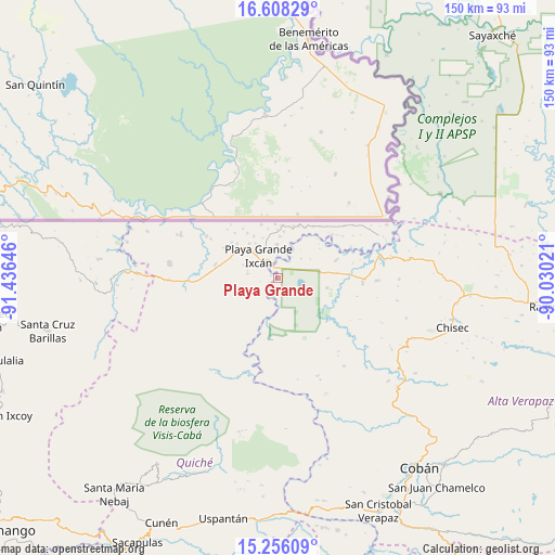
Playa Grande GPS coordinates[2]
15° 55' 59.988" North, 90° 43' 59.988" West
| Map corner | latitude | longitude |
|---|---|---|
| Upper-left | 16.60829°, | -91.43646° |
| Center: | 15.93333°, | -90.73333° |
| Lower-right: | 15.25609°, | -90.03021° |
| Map W x H: | 150.4×150.4 km | = 93.5×93.5mi |
| max Lat: | 17.06606° ⇑3.8% North |
| Playa Grande: | 15.93333° |
| min Lat: | ⇓96.2% South 13.9274° |
| min Long | Playa Grande | max Long |
| -92.19298° | -90.73333° | -88.59444° |
| W 58.7%⇐ | ⇒41.3% E |
Elevation
Elevation of Playa Grande is 185 m = 607 ft, and this is 1082 m = 3550 ft below average elevation for this country.
| Max E: |
3254 m = 10676 ft | 90% |
| Avg. | 1267 m = 4157 ft | |
| Playa Grande | 185 m = 607 ft | |
Min E: |
1 m = 3 ft | 10% |
See also: Guatemala elevation on elevation.city.
Geographical zone
Playa Grande is located in North Torrid zone (between Equator and Tropic of Cancer). Distance of this Northern Tropic circle is 834.3 km =518.4 mi to North.| Distance of | km | miles | from Playa Grande |
|---|---|---|---|
| North Pole | 8235.4 | 5117.2 | to North |
| Arctic Circle | 5629.6 | 3498.1 | to North |
| Tropic Cancer | 834.3 | 518.4 | to North |
| Equator | 1771.6 | 1100.8 | to South |


Nearby cities:
15 places around Playa Grande: (largest is in red/bold)
• Barillas
63.9 km =39.7 mi,  256°
256°
• Chajul
59.4 km =36.9 mi,  212°
212°
• Chicamán
65.5 km =40.7 mi,  186°
186°
• Chisec
49.8 km =30.9 mi,  105°
105°
• Cobán
64.4 km =40 mi,  142°
142°
• Cunén
73.5 km =45.7 mi, 205°
• Nebaj
73.5 km =45.7 mi,  217°
217°
• Raxruhá
75.2 km =46.7 mi,  95°
95°
• San Cristóbal Verapaz
62.4 km =38.8 mi,  163°
163°
• San Juan Chamelco
70.2 km =43.6 mi, 142°
• San Juan Cotzal
64.2 km =39.9 mi, 210°
• San Luis Ixcán
42 km =26.1 mi,  247°
247°
• San Pedro Carchá
70.7 km =43.9 mi, 135°
• Santa Cruz Verapaz
70.7 km =43.9 mi,  152°
152°
• Uspantán
66.9 km =41.6 mi, 192°
Sources, notices
• [Note1] Compared only with cities in Guatemala existing in our database
• [Src1] Map data: © OpenStreetMap contributors (CC-BY-SA)
• [Src2] Other city data from geonames.org with taken over terms of usage.
• [Src3] Geographical zone / Annual Mean Temperature by Robert A. Rohde @ Wikipedia
