Flores geodata
Flores (Petén) is a seat of a first-order administrative division; located in Guatemala in America/Guatemala (GMT-6) time zone. With population of 20,464 people, there are 53 cities with bigger population in this country. Compared to other cities in Guatemala, 99.1% of cities are located further ↓South; 84.1% of cities are located further ←West and 94.4% of cities have higher elevation than Flores. Note1


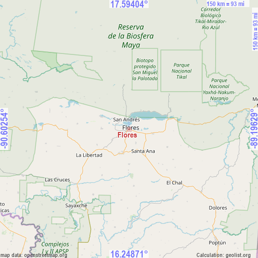
Flores GPS coordinates[2]
16° 55' 21.288" North, 89° 53' 57.876" West
| Map corner | latitude | longitude |
|---|---|---|
| Upper-left | 17.59404°, | -90.60254° |
| Center: | 16.92258°, | -89.89941° |
| Lower-right: | 16.24871°, | -89.19629° |
| Map W x H: | 149.6×149.6 km | = 93×93mi |
| max Lat: | 17.06606° ⇑0.9% North |
| Flores: | 16.92258° |
| min Lat: | ⇓99.1% South 13.9274° |
| min Long | Flores | max Long |
| -92.19298° | -89.89941° | -88.59444° |
| W 84.1%⇐ | ⇒15.9% E |
Elevation
Elevation of Flores is 121 m = 397 ft, and this is 1146 m = 3760 ft below average elevation for this country.
| Max E: |
3254 m = 10676 ft | 94.4% |
| Avg. | 1267 m = 4157 ft | |
| Flores | 121 m = 397 ft | |
Min E: |
1 m = 3 ft | 5.6% |
See also: Guatemala elevation on elevation.city.
Geographical zone
Flores is located in North Torrid zone (between Equator and Tropic of Cancer). Distance of this Northern Tropic circle is 724.3 km =450.1 mi to North.| Distance of | km | miles | from Flores |
|---|---|---|---|
| North Pole | 8125.4 | 5048.9 | to North |
| Arctic Circle | 5519.6 | 3429.7 | to North |
| Tropic Cancer | 724.3 | 450.1 | to North |
| Equator | 1881.6 | 1169.2 | to South |


Nearby cities:
15 places around Flores: (largest is in red/bold)
• Chisec
129.6 km =80.5 mi,  198°
198°
• Dolores
68.7 km =42.7 mi,  131°
131°
• El Chal
40.7 km =25.3 mi,  139°
139°
• Fray Bartolomé de Las Casas
123.1 km =76.5 mi,  179°
179°
• La Libertad
27.5 km =17.1 mi,  237°
237°
• Melchor de Mencos
81 km =50.3 mi,  78°
78°
• Poptún
83.5 km =51.9 mi, 141°
• Raxruhá
118.3 km =73.5 mi,  186°
186°
• San Andrés
5.2 km =3.2 mi,  339°
339°
• San Benito
2.2 km =1.4 mi,  252°
252°
• San Francisco
14.1 km =8.8 mi, 194°
• San José
6.8 km =4.2 mi,  359°
359°
• San Luis
94.2 km =58.5 mi,  148°
148°
• Santa Ana
15.3 km =9.5 mi, 152°
• Sayaxché
53.9 km =33.5 mi,  214°
214°
Sources, notices
• [Note1] Compared only with cities in Guatemala existing in our database
• [Src1] Map data: © OpenStreetMap contributors (CC-BY-SA)
• [Src2] Other city data from geonames.org with taken over terms of usage.
• [Src3] Geographical zone / Annual Mean Temperature by Robert A. Rohde @ Wikipedia
