El Chal geodata
El Chal (Petén) is a seat of a second-order administrative division; located in Guatemala in America/Guatemala (GMT-6) time zone. In our database, there are 325 cities with bigger population. Compared to other cities in Guatemala, 97.6% of cities are located further ↓South; 91.7% of cities are located further ←West and 85% of cities have higher elevation than El Chal. Note1


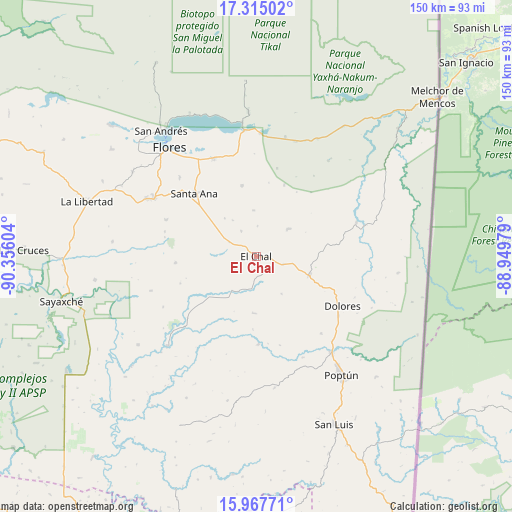
El Chal GPS coordinates[2]
16° 38' 33.18" North, 89° 39' 10.476" West
| Map corner | latitude | longitude |
|---|---|---|
| Upper-left | 17.31502°, | -90.35604° |
| Center: | 16.64255°, | -89.65291° |
| Lower-right: | 15.96771°, | -88.94979° |
| Map W x H: | 149.8×149.8 km | = 93.1×93.1mi |
| max Lat: | 17.06606° ⇑2.4% North |
| El Chal: | 16.64255° |
| min Lat: | ⇓97.6% South 13.9274° |
| min Long | El Chal | max Long |
| -92.19298° | -89.65291° | -88.59444° |
| W 91.7%⇐ | ⇒8.3% E |
Elevation
Elevation of El Chal is 265 m = 869 ft, and this is 1002 m = 3287 ft below average elevation for this country.
| Max E: |
3254 m = 10676 ft | 85% |
| Avg. | 1267 m = 4157 ft | |
| El Chal | 265 m = 869 ft | |
Min E: |
1 m = 3 ft | 15% |
See also: Guatemala elevation on elevation.city.
Geographical zone
El Chal is located in North Torrid zone (between Equator and Tropic of Cancer). Distance of this Northern Tropic circle is 755.4 km =469.4 mi to North.| Distance of | km | miles | from El Chal |
|---|---|---|---|
| North Pole | 8156.6 | 5068.3 | to North |
| Arctic Circle | 5550.7 | 3449 | to North |
| Tropic Cancer | 755.4 | 469.4 | to North |
| Equator | 1850.5 | 1149.8 | to South |


Nearby cities:
15 places around El Chal: (largest is in red/bold)
• Chahal Guatemala
94.8 km =58.9 mi,  176°
176°
• Dolores
29 km =18 mi,  120°
120°
• Flores
40.7 km =25.3 mi,  319°
319°
• Fray Bartolomé de Las Casas
95.4 km =59.3 mi,  195°
195°
• La Libertad
52 km =32.3 mi,  288°
288°
• Melchor de Mencos
71.1 km =44.2 mi,  48°
48°
• Poptún
42.8 km =26.6 mi,  144°
144°
• Raxruhá
95.3 km =59.2 mi,  205°
205°
• San Andrés
45.7 km =28.4 mi, 322°
• San Benito
41.6 km =25.8 mi, 317°
• San Francisco
34.6 km =21.5 mi,  300°
300°
• San José
46.1 km =28.6 mi,  325°
325°
• San Luis
54.3 km =33.7 mi,  155°
155°
• Santa Ana
26 km =16.2 mi,  312°
312°
• Sayaxché
58.5 km =36.4 mi,  257°
257°
Sources, notices
• [Note1] Compared only with cities in Guatemala existing in our database
• [Src1] Map data: © OpenStreetMap contributors (CC-BY-SA)
• [Src2] Other city data from geonames.org with taken over terms of usage.
• [Src3] Geographical zone / Annual Mean Temperature by Robert A. Rohde @ Wikipedia
