San Benito geodata
San Benito (Petén) is a seat of a second-order administrative division; located in Guatemala in America/Guatemala (GMT-6) time zone. With population of 30,764 people, there are 36 cities with bigger population in this country. Compared to other cities in Guatemala, 98.8% of cities are located further ↓South; 82.6% of cities are located further ←West and 93.2% of cities have higher elevation than San Benito. Note1


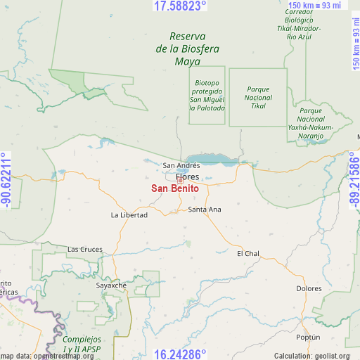
San Benito GPS coordinates[2]
16° 55' 0.3" North, 89° 55' 8.328" West
| Map corner | latitude | longitude |
|---|---|---|
| Upper-left | 17.58823°, | -90.62211° |
| Center: | 16.91675°, | -89.91898° |
| Lower-right: | 16.24286°, | -89.21586° |
| Map W x H: | 149.6×149.6 km | = 93×93mi |
| max Lat: | 17.06606° ⇑1.2% North |
| San Benito: | 16.91675° |
| min Lat: | ⇓98.8% South 13.9274° |
| min Long | San Benito | max Long |
| -92.19298° | -89.91898° | -88.59444° |
| W 82.6%⇐ | ⇒17.4% E |
Elevation
Elevation of San Benito is 135 m = 443 ft, and this is 1132 m = 3714 ft below average elevation for this country.
| Max E: |
3254 m = 10676 ft | 93.2% |
| Avg. | 1267 m = 4157 ft | |
| San Benito | 135 m = 443 ft | |
Min E: |
1 m = 3 ft | 6.8% |
See also: Guatemala elevation on elevation.city.
Geographical zone
San Benito is located in North Torrid zone (between Equator and Tropic of Cancer). Distance of this Northern Tropic circle is 725 km =450.5 mi to North.| Distance of | km | miles | from San Benito |
|---|---|---|---|
| North Pole | 8126.1 | 5049.3 | to North |
| Arctic Circle | 5520.2 | 3430.1 | to North |
| Tropic Cancer | 725 | 450.5 | to North |
| Equator | 1881 | 1168.8 | to South |


Nearby cities:
15 places around San Benito: (largest is in red/bold)
• Chisec
128.3 km =79.7 mi,  197°
197°
• Dolores
69.9 km =43.4 mi,  130°
130°
• El Chal
41.6 km =25.8 mi,  137°
137°
• Flores
2.2 km =1.4 mi,  72°
72°
• Fray Bartolomé de Las Casas
122.5 km =76.1 mi,  178°
178°
• La Libertad
25.4 km =15.8 mi,  235°
235°
• Melchor de Mencos
83.2 km =51.7 mi,  78°
78°
• Poptún
84.3 km =52.4 mi, 140°
• Raxruhá
117.4 km =72.9 mi,  185°
185°
• San Andrés
5.6 km =3.5 mi,  2°
2°
• San Francisco
13.1 km =8.1 mi, 186°
• San José
7.7 km =4.8 mi,  15°
15°
• San Luis
94.7 km =58.8 mi,  147°
147°
• Santa Ana
15.9 km =9.9 mi, 144°
• Sayaxché
52.2 km =32.4 mi,  213°
213°
Sources, notices
• [Note1] Compared only with cities in Guatemala existing in our database
• [Src1] Map data: © OpenStreetMap contributors (CC-BY-SA)
• [Src2] Other city data from geonames.org with taken over terms of usage.
• [Src3] Geographical zone / Annual Mean Temperature by Robert A. Rohde @ Wikipedia
