San Luis geodata
San Luis (Petén) is a seat of a second-order administrative division; located in Guatemala in America/Guatemala (GMT-6) time zone. With population of 6,776 people, there are 177 cities with bigger population in this country. Compared to other cities in Guatemala, 96.5% of cities are located further ↓South; 95.6% of cities are located further ←West and 79.1% of cities have higher elevation than San Luis. Note1


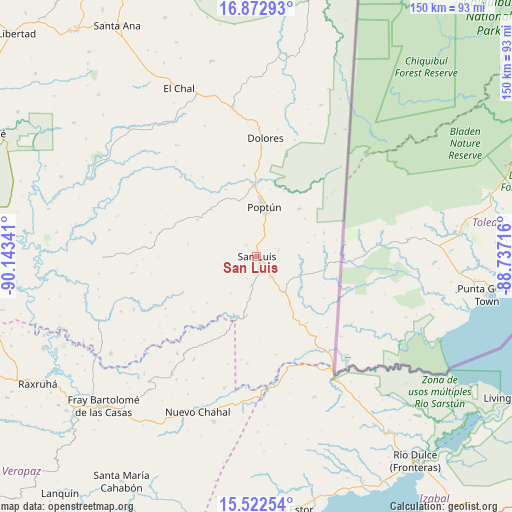
San Luis GPS coordinates[2]
16° 11' 56.004" North, 89° 26' 25.008" West
| Map corner | latitude | longitude |
|---|---|---|
| Upper-left | 16.87293°, | -90.14341° |
| Center: | 16.19889°, | -89.44028° |
| Lower-right: | 15.52254°, | -88.73716° |
| Map W x H: | 150.1×150.2 km | = 93.3×93.3mi |
| max Lat: | 17.06606° ⇑3.5% North |
| San Luis: | 16.19889° |
| min Lat: | ⇓96.5% South 13.9274° |
| min Long | San Luis | max Long |
| -92.19298° | -89.44028° | -88.59444° |
| W 95.6%⇐ | ⇒4.4% E |
Elevation
Elevation of San Luis is 381 m = 1250 ft, and this is 886 m = 2907 ft below average elevation for this country.
| Max E: |
3254 m = 10676 ft | 79.1% |
| Avg. | 1267 m = 4157 ft | |
| San Luis | 381 m = 1250 ft | |
Min E: |
1 m = 3 ft | 20.9% |
See also: Guatemala elevation on elevation.city.
Geographical zone
San Luis is located in North Torrid zone (between Equator and Tropic of Cancer). Distance of this Northern Tropic circle is 804.8 km =500.1 mi to North.| Distance of | km | miles | from San Luis |
|---|---|---|---|
| North Pole | 8205.9 | 5098.9 | to North |
| Arctic Circle | 5600 | 3479.7 | to North |
| Tropic Cancer | 804.8 | 500.1 | to North |
| Equator | 1801.1 | 1119.2 | to South |


Nearby cities:
15 places around San Luis: (largest is in red/bold)
• Cahabón
81 km =50.3 mi,  209°
209°
• Chahal Guatemala
48.6 km =30.2 mi,  201°
201°
• Dolores
34.9 km =21.7 mi,  4°
4°
• El Chal
54.3 km =33.7 mi,  335°
335°
• El Estor
74.6 km =46.4 mi,  172°
172°
• Flores
94.2 km =58.5 mi,  328°
328°
• Fray Bartolomé de Las Casas
64.2 km =39.9 mi,  228°
228°
• Lanquín
90.1 km =56 mi,  218°
218°
• Lívingston
84.5 km =52.5 mi,  119°
119°
• Panzós
92.1 km =57.2 mi, 195°
• Poptún
14.9 km =9.3 mi,  9°
9°
• Raxruhá
73.4 km =45.6 mi,  239°
239°
• San Francisco
85 km =52.8 mi,  321°
321°
• Santa Ana
78.9 km =49 mi, 327°
• Sayaxché
87.6 km =54.4 mi,  294°
294°
Sources, notices
• [Note1] Compared only with cities in Guatemala existing in our database
• [Src1] Map data: © OpenStreetMap contributors (CC-BY-SA)
• [Src2] Other city data from geonames.org with taken over terms of usage.
• [Src3] Geographical zone / Annual Mean Temperature by Robert A. Rohde @ Wikipedia
