Chisec geodata
Chisec (Alta Verapaz) is a seat of a second-order administrative division; located in Guatemala in America/Guatemala (GMT-6) time zone. With population of 17,018 people, there are 71 cities with bigger population in this country. Compared to other cities in Guatemala, 94.7% of cities are located further ↓South; 73.5% of cities are located further ←West and 88.5% of cities have higher elevation than Chisec. Note1


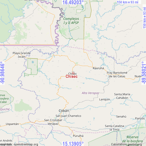
Chisec GPS coordinates[2]
15° 49' 0.012" North, 90° 16' 59.988" West
| Map corner | latitude | longitude |
|---|---|---|
| Upper-left | 16.49203°, | -90.98646° |
| Center: | 15.81667°, | -90.28333° |
| Lower-right: | 15.13905°, | -89.58021° |
| Map W x H: | 150.4×150.4 km | = 93.5×93.5mi |
| max Lat: | 17.06606° ⇑5.3% North |
| Chisec: | 15.81667° |
| min Lat: | ⇓94.7% South 13.9274° |
| min Long | Chisec | max Long |
| -92.19298° | -90.28333° | -88.59444° |
| W 73.5%⇐ | ⇒26.5% E |
Elevation
Elevation of Chisec is 219 m = 719 ft, and this is 1048 m = 3438 ft below average elevation for this country.
| Max E: |
3254 m = 10676 ft | 88.5% |
| Avg. | 1267 m = 4157 ft | |
| Chisec | 219 m = 719 ft | |
Min E: |
1 m = 3 ft | 11.5% |
See also: Guatemala elevation on elevation.city.
Geographical zone
Chisec is located in North Torrid zone (between Equator and Tropic of Cancer). Distance of this Northern Tropic circle is 847.3 km =526.5 mi to North.| Distance of | km | miles | from Chisec |
|---|---|---|---|
| North Pole | 8248.4 | 5125.3 | to North |
| Arctic Circle | 5642.5 | 3506.1 | to North |
| Tropic Cancer | 847.3 | 526.5 | to North |
| Equator | 1758.6 | 1092.7 | to South |


Nearby cities:
15 places around Chisec: (largest is in red/bold)
• Cahabón
57.2 km =35.5 mi,  119°
119°
• Cobán
39.6 km =24.6 mi,  193°
193°
• Fray Bartolomé de Las Casas
42.2 km =26.2 mi,  90°
90°
• Lanquín
43.8 km =27.2 mi,  129°
129°
• Playa Grande
49.8 km =30.9 mi,  285°
285°
• Purulhá
61.8 km =38.4 mi,  171°
171°
• Raxruhá
27.3 km =17 mi,  78°
78°
• San Cristóbal Verapaz
55.6 km =34.5 mi,  212°
212°
• San Juan Chamelco
43 km =26.7 mi, 187°
• San Pedro Carchá
37.1 km =23.1 mi,  177°
177°
• Santa Cruz Verapaz
52.6 km =32.7 mi,  197°
197°
• Senahú
66.8 km =41.5 mi, 133°
• Tactic
55.5 km =34.5 mi, 187°
• Tamahú
56.7 km =35.2 mi, 174°
• Tucurú
62 km =38.5 mi,  158°
158°
Sources, notices
• [Note1] Compared only with cities in Guatemala existing in our database
• [Src1] Map data: © OpenStreetMap contributors (CC-BY-SA)
• [Src2] Other city data from geonames.org with taken over terms of usage.
• [Src3] Geographical zone / Annual Mean Temperature by Robert A. Rohde @ Wikipedia
