Poptún geodata
Poptún (Petén) is a seat of a second-order administrative division; located in Guatemala in America/Guatemala (GMT-6) time zone. With population of 17,320 people, there are 70 cities with bigger population in this country. Compared to other cities in Guatemala, 96.8% of cities are located further ↓South; 96.5% of cities are located further ←West and 72.6% of cities have higher elevation than Poptún. Note1


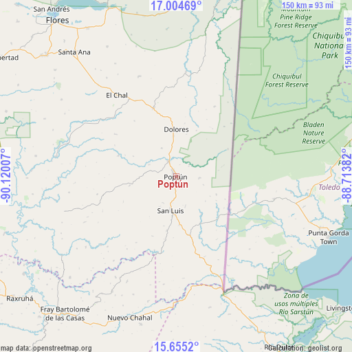
Poptún GPS coordinates[2]
16° 19' 51.996" North, 89° 25' 0.984" West
| Map corner | latitude | longitude |
|---|---|---|
| Upper-left | 17.00469°, | -90.12007° |
| Center: | 16.33111°, | -89.41694° |
| Lower-right: | 15.6552°, | -88.71382° |
| Map W x H: | 150×150.1 km | = 93.2×93.3mi |
| max Lat: | 17.06606° ⇑3.2% North |
| Poptún: | 16.33111° |
| min Lat: | ⇓96.8% South 13.9274° |
| min Long | Poptún | max Long |
| -92.19298° | -89.41694° | -88.59444° |
| W 96.5%⇐ | ⇒3.5% E |
Elevation
Elevation of Poptún is 533 m = 1749 ft, and this is 734 m = 2408 ft below average elevation for this country.
| Max E: |
3254 m = 10676 ft | 72.6% |
| Avg. | 1267 m = 4157 ft | |
| Poptún | 533 m = 1749 ft | |
Min E: |
1 m = 3 ft | 27.4% |
See also: Guatemala elevation on elevation.city.
Geographical zone
Poptún is located in North Torrid zone (between Equator and Tropic of Cancer). Distance of this Northern Tropic circle is 790.1 km =490.9 mi to North.| Distance of | km | miles | from Poptún |
|---|---|---|---|
| North Pole | 8191.2 | 5089.8 | to North |
| Arctic Circle | 5585.3 | 3470.5 | to North |
| Tropic Cancer | 790.1 | 490.9 | to North |
| Equator | 1815.8 | 1128.3 | to South |


Nearby cities:
15 places around Poptún: (largest is in red/bold)
• Chahal Guatemala
63.3 km =39.3 mi,  198°
198°
• Dolores
20.1 km =12.5 mi,  359°
359°
• El Chal
42.8 km =26.6 mi,  324°
324°
• El Estor
89 km =55.3 mi,  175°
175°
• Flores
83.5 km =51.9 mi, 321°
• Fray Bartolomé de Las Casas
76.4 km =47.5 mi,  221°
221°
• Melchor de Mencos
86.4 km =53.7 mi,  19°
19°
• Raxruhá
83.7 km =52 mi,  231°
231°
• San Andrés
88.5 km =55 mi, 323°
• San Benito
84.3 km =52.4 mi, 320°
• San Francisco
75.8 km =47.1 mi,  313°
313°
• San José
88.9 km =55.2 mi, 324°
• San Luis
14.9 km =9.3 mi,  189°
189°
• Santa Ana
68.5 km =42.6 mi, 319°
• Sayaxché
85 km =52.8 mi,  284°
284°
Sources, notices
• [Note1] Compared only with cities in Guatemala existing in our database
• [Src1] Map data: © OpenStreetMap contributors (CC-BY-SA)
• [Src2] Other city data from geonames.org with taken over terms of usage.
• [Src3] Geographical zone / Annual Mean Temperature by Robert A. Rohde @ Wikipedia
