Santa Ana geodata
Santa Ana (Petén) is a seat of a second-order administrative division; located in Guatemala in America/Guatemala (GMT-6) time zone. With population of 9,523 people, there are 134 cities with bigger population in this country. Compared to other cities in Guatemala, 98.2% of cities are located further ↓South; 86.4% of cities are located further ←West and 89.1% of cities have higher elevation than Santa Ana. Note1


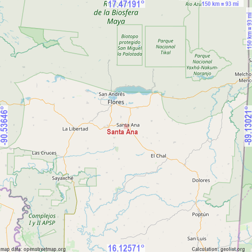
Santa Ana GPS coordinates[2]
16° 48' 0" North, 89° 49' 59.988" West
| Map corner | latitude | longitude |
|---|---|---|
| Upper-left | 17.47191°, | -90.53646° |
| Center: | 16.8°, | -89.83333° |
| Lower-right: | 16.12571°, | -89.13021° |
| Map W x H: | 149.7×149.7 km | = 93×93mi |
| max Lat: | 17.06606° ⇑1.8% North |
| Santa Ana: | 16.8° |
| min Lat: | ⇓98.2% South 13.9274° |
| min Long | Santa Ana | max Long |
| -92.19298° | -89.83333° | -88.59444° |
| W 86.4%⇐ | ⇒13.6% E |
Elevation
Elevation of Santa Ana is 213 m = 699 ft, and this is 1054 m = 3458 ft below average elevation for this country.
| Max E: |
3254 m = 10676 ft | 89.1% |
| Avg. | 1267 m = 4157 ft | |
| Santa Ana | 213 m = 699 ft | |
Min E: |
1 m = 3 ft | 10.9% |
See also: Guatemala elevation on elevation.city.
Geographical zone
Santa Ana is located in North Torrid zone (between Equator and Tropic of Cancer). Distance of this Northern Tropic circle is 737.9 km =458.5 mi to North.| Distance of | km | miles | from Santa Ana |
|---|---|---|---|
| North Pole | 8139.1 | 5057.4 | to North |
| Arctic Circle | 5533.2 | 3438.2 | to North |
| Tropic Cancer | 737.9 | 458.5 | to North |
| Equator | 1868 | 1160.7 | to South |


Nearby cities:
15 places around Santa Ana: (largest is in red/bold)
• Chahal Guatemala
114.8 km =71.3 mi,  167°
167°
• Dolores
54.7 km =34 mi,  125°
125°
• El Chal
26 km =16.2 mi, 132°
• Flores
15.3 km =9.5 mi,  332°
332°
• Fray Bartolomé de Las Casas
109.7 km =68.2 mi,  183°
183°
• La Libertad
30.2 km =18.8 mi,  267°
267°
• Melchor de Mencos
78.2 km =48.6 mi,  67°
67°
• Poptún
68.5 km =42.6 mi,  139°
139°
• Raxruhá
105.9 km =65.8 mi,  191°
191°
• San Andrés
20.5 km =12.7 mi, 334°
• San Benito
15.9 km =9.9 mi,  324°
324°
• San Francisco
10.6 km =6.6 mi, 270°
• San José
21.6 km =13.4 mi,  340°
340°
• San Luis
78.9 km =49 mi,  147°
147°
• Sayaxché
48.6 km =30.2 mi,  230°
230°
Sources, notices
• [Note1] Compared only with cities in Guatemala existing in our database
• [Src1] Map data: © OpenStreetMap contributors (CC-BY-SA)
• [Src2] Other city data from geonames.org with taken over terms of usage.
• [Src3] Geographical zone / Annual Mean Temperature by Robert A. Rohde @ Wikipedia
