Melchor de Mencos geodata
Melchor de Mencos (Petén) is a populated place; located in Guatemala in America/Guatemala (GMT-6) time zone. With population of 11,457 people, there are 110 cities with bigger population in this country. Compared to other cities in Guatemala, 100% of cities are located further ↓South; 98.8% of cities are located further ←West and 95% of cities have higher elevation than Melchor de Mencos. Note1


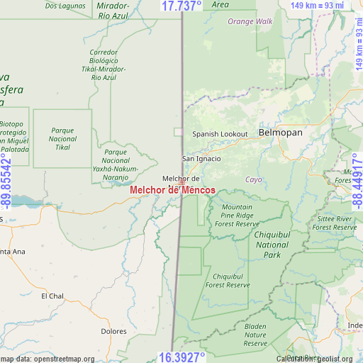
Melchor de Mencos GPS coordinates[2]
17° 3' 57.816" North, 89° 9' 8.244" West
| Map corner | latitude | longitude |
|---|---|---|
| Upper-left | 17.737°, | -89.85542° |
| Center: | 17.06606°, | -89.15229° |
| Lower-right: | 16.3927°, | -88.44917° |
| Map W x H: | 149.5×149.5 km | = 92.9×92.9mi |
| max Lat: | 17.06606° ⇑0% North |
| Melchor de Mencos: | 17.06606° |
| min Lat: | ⇓100% South 13.9274° |
| min Long | Melchor de Menc | max Long |
| -92.19298° | -89.15229° | -88.59444° |
| W 98.8%⇐ | ⇒1.2% E |
Elevation
Elevation of Melchor de Mencos is 113 m = 371 ft, and this is 1154 m = 3786 ft below average elevation for this country.
| Max E: |
3254 m = 10676 ft | 95% |
| Avg. | 1267 m = 4157 ft | |
| Melchor de Mencos | 113 m = 371 ft | |
Min E: |
1 m = 3 ft | 5% |
See also: Guatemala elevation on elevation.city.
Geographical zone
Melchor de Mencos is located in North Torrid zone (between Equator and Tropic of Cancer). Distance of this Northern Tropic circle is 708.4 km =440.2 mi to North.| Distance of | km | miles | from Melchor de Mencos |
|---|---|---|---|
| North Pole | 8109.5 | 5039 | to North |
| Arctic Circle | 5503.6 | 3419.8 | to North |
| Tropic Cancer | 708.4 | 440.2 | to North |
| Equator | 1897.6 | 1179.1 | to South |


Nearby cities:
15 places around Melchor de Mencos: (largest is in red/bold)
• Chahal Guatemala
149.8 km =93.1 mi,  198°
198°
• Dolores
67.8 km =42.1 mi, 204°
• El Chal
71.1 km =44.2 mi,  228°
228°
• Flores
81 km =50.3 mi,  258°
258°
• Fray Bartolomé de Las Casas
159.8 km =99.3 mi,  209°
209°
• La Libertad
107.2 km =66.6 mi,  253°
253°
• Lívingston
144.1 km =89.5 mi,  162°
162°
• Poptún
86.4 km =53.7 mi, 199°
• San Andrés
82 km =51 mi, 262°
• San Benito
83.2 km =51.7 mi, 258°
• San Francisco
88.2 km =54.8 mi, 250°
• San José
80 km =49.7 mi, 263°
• San Luis
101.2 km =62.9 mi, 197°
• Santa Ana
78.2 km =48.6 mi, 247°
• Sayaxché
125.6 km =78 mi,  241°
241°
Sources, notices
• [Note1] Compared only with cities in Guatemala existing in our database
• [Src1] Map data: © OpenStreetMap contributors (CC-BY-SA)
• [Src2] Other city data from geonames.org with taken over terms of usage.
• [Src3] Geographical zone / Annual Mean Temperature by Robert A. Rohde @ Wikipedia
