Huehuetenango geodata
Huehuetenango is a seat of a first-order administrative division; located in Guatemala in America/Guatemala (GMT-6) time zone. With population of 79,426 people, there are 11 cities with bigger population in this country. Compared to other cities in Guatemala, 80.2% of cities are located further ↓South; 71.1% of cities are located further →East and 72.6% of cities have lower elevation than Huehuetenango. Note1


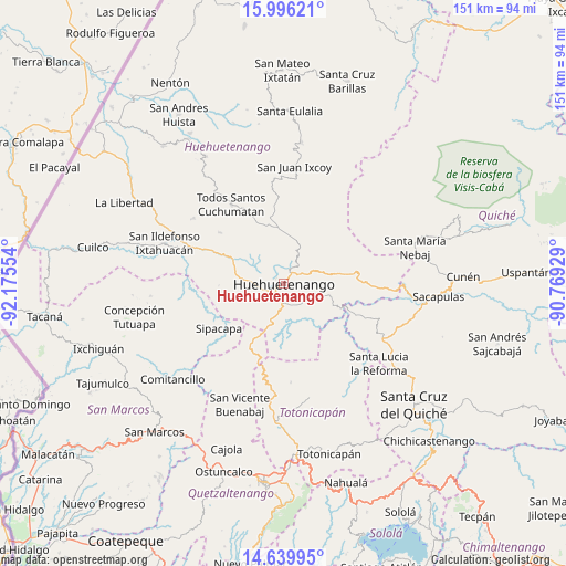
Huehuetenango GPS coordinates[2]
15° 19' 9.048" North, 91° 28' 20.676" West
| Map corner | latitude | longitude |
|---|---|---|
| Upper-left | 15.99621°, | -92.17554° |
| Center: | 15.31918°, | -91.47241° |
| Lower-right: | 14.63995°, | -90.76929° |
| Map W x H: | 150.8×150.8 km | = 93.7×93.7mi |
| max Lat: | 17.06606° ⇑19.8% North |
| Huehuetenango: | 15.31918° |
| min Lat: | ⇓80.2% South 13.9274° |
| min Long | Huehuetenango | max Long |
| -92.19298° | -91.47241° | -88.59444° |
| W 28.9%⇐ | ⇒71.1% E |
Elevation
Elevation of Huehuetenango is 1896 m = 6220 ft, and this is 629 m = 2064 ft above average elevation for this country.
| Max E: |
3254 m = 10676 ft | 27.4% |
| Huehuetenango | 1896 m 6220 ft | |
| Avg. | 1267 m = 4157 ft | |
Min E: |
1 m = 3 ft | 72.6% |
See also: Huehuetenango elevation on elevation.city.
Geographical zone
Huehuetenango is located in North Torrid zone (between Equator and Tropic of Cancer). Distance of this Northern Tropic circle is 902.6 km =560.8 mi to North.| Distance of | km | miles | from Huehuetenango |
|---|---|---|---|
| North Pole | 8303.7 | 5159.7 | to North |
| Arctic Circle | 5697.8 | 3540.4 | to North |
| Tropic Cancer | 902.6 | 560.8 | to North |
| Equator | 1703.3 | 1058.4 | to South |


Nearby cities:
15 places around Huehuetenango: (largest is in red/bold)
• Aguacatán
17.5 km =10.9 mi,  81°
81°
• Chiantla
4.3 km =2.7 mi,  21°
21°
• Colotenango
27.5 km =17.1 mi,  290°
290°
• Malacatancito
8.8 km =5.5 mi,  198°
198°
• Momostenango
31.3 km =19.4 mi,  167°
167°
• San Bartolo
26.2 km =16.3 mi,  176°
176°
• San Gaspar Ixchil
28.2 km =17.5 mi, 285°
• San Juan Atitán
20.3 km =12.6 mi,  306°
306°
• San Miguel Ixtahuacán
30 km =18.6 mi,  260°
260°
• San Rafael Petzal
22.7 km =14.1 mi, 294°
• San Sebastián Huehuetenango
17.1 km =10.6 mi,  296°
296°
• Santa Bárbara
17.2 km =10.7 mi,  268°
268°
• Santiago Chimaltenango
29.7 km =18.5 mi, 306°
• Sipacapa
21 km =13 mi,  235°
235°
• Todos Santos Cuchumatán
25.3 km =15.7 mi,  326°
326°
Sources, notices
• [Note1] Compared only with cities in Guatemala existing in our database
• [Src1] Map data: © OpenStreetMap contributors (CC-BY-SA)
• [Src2] Other city data from geonames.org with taken over terms of usage.
• [Src3] Geographical zone / Annual Mean Temperature by Robert A. Rohde @ Wikipedia
