San Raimundo geodata
San Raimundo (Guatemala) is a seat of a second-order administrative division; located in Guatemala in America/Guatemala (GMT-6) time zone. With population of 8,689 people, there are 148 cities with bigger population in this country. Compared to other cities in Guatemala, 54.3% of cities are located further ↑North; 64% of cities are located further ←West and 61.7% of cities have lower elevation than San Raimundo. Note1


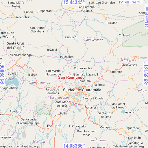
San Raimundo GPS coordinates[2]
14° 45' 52.632" North, 90° 35' 41.748" West
| Map corner | latitude | longitude |
|---|---|---|
| Upper-left | 15.44345°, | -91.29806° |
| Center: | 14.76462°, | -90.59493° |
| Lower-right: | 14.08366°, | -89.89181° |
| Map W x H: | 151.2×151.2 km | = 94×94mi |
| max Lat: | 17.06606° ⇑54.3% North |
| San Raimundo: | 14.76462° |
| min Lat: | ⇓45.7% South 13.9274° |
| min Long | San Raimundo | max Long |
| -92.19298° | -90.59493° | -88.59444° |
| W 64%⇐ | ⇒36% E |
Elevation
Elevation of San Raimundo is 1579 m = 5180 ft, and this is 312 m = 1024 ft above average elevation for this country.
| Max E: |
3254 m = 10676 ft | 38.3% |
| San Raimundo | 1579 m 5180 ft | |
| Avg. | 1267 m = 4157 ft | |
Min E: |
1 m = 3 ft | 61.7% |
See also: Guatemala elevation on elevation.city.
Geographical zone
San Raimundo is located in North Torrid zone (between Equator and Tropic of Cancer). Distance of this Northern Tropic circle is 964.2 km =599.1 mi to North.| Distance of | km | miles | from San Raimundo |
|---|---|---|---|
| North Pole | 8365.4 | 5198 | to North |
| Arctic Circle | 5759.5 | 3578.8 | to North |
| Tropic Cancer | 964.2 | 599.1 | to North |
| Equator | 1641.7 | 1020.1 | to South |


Nearby cities:
15 places around San Raimundo: (largest is in red/bold)
• Chinautla
12.3 km =7.6 mi,  123°
123°
• Chuarrancho
10.4 km =6.5 mi,  55°
55°
• Granados
18.6 km =11.6 mi,  24°
24°
• Guatemala City
16.3 km =10.1 mi,  147°
147°
• Mixco
14.9 km =9.3 mi,  185°
185°
• Pachalum
19.2 km =11.9 mi,  337°
337°
• San Bartolomé Milpas Altas
19.7 km =12.2 mi,  207°
207°
• San Juan Sacatepéquez
7.3 km =4.5 mi,  226°
226°
• San Lucas Sacatepéquez
18.4 km =11.4 mi,  201°
201°
• San Martín Jilotepeque
21.3 km =13.2 mi,  274°
274°
• San Pedro Ayampuc
15.3 km =9.5 mi,  83°
83°
• San Pedro Sacatepéquez
10.1 km =6.3 mi, 210°
• Santiago Sacatepéquez
16.9 km =10.5 mi, 211°
• Santo Domingo Xenacoj
14.7 km =9.1 mi, 230°
• Sumpango
19.9 km =12.4 mi, 228°
Sources, notices
• [Note1] Compared only with cities in Guatemala existing in our database
• [Src1] Map data: © OpenStreetMap contributors (CC-BY-SA)
• [Src2] Other city data from geonames.org with taken over terms of usage.
• [Src3] Geographical zone / Annual Mean Temperature by Robert A. Rohde @ Wikipedia
