Chinautla geodata
Chinautla (Guatemala) is a seat of a second-order administrative division; located in Guatemala in America/Guatemala (GMT-6) time zone. With population of 97,172 people, there are 8 cities with bigger population in this country. Compared to other cities in Guatemala, 59.9% of cities are located further ↑North; 66.4% of cities are located further ←West and 51% of cities have higher elevation than Chinautla. Note1


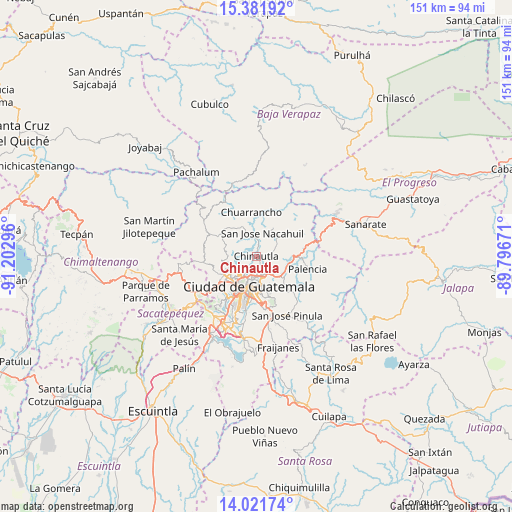
Chinautla GPS coordinates[2]
14° 42' 10.404" North, 90° 29' 59.388" West
| Map corner | latitude | longitude |
|---|---|---|
| Upper-left | 15.38192°, | -91.20296° |
| Center: | 14.70289°, | -90.49983° |
| Lower-right: | 14.02174°, | -89.79671° |
| Map W x H: | 151.2×151.2 km | = 94×94mi |
| max Lat: | 17.06606° ⇑59.9% North |
| Chinautla: | 14.70289° |
| min Lat: | ⇓40.1% South 13.9274° |
| min Long | Chinautla | max Long |
| -92.19298° | -90.49983° | -88.59444° |
| W 66.4%⇐ | ⇒33.6% E |
Elevation
Elevation of Chinautla is 1233 m = 4045 ft, and this is 34 m = 112 ft below average elevation for this country.
| Max E: |
3254 m = 10676 ft | 51% |
| Avg. | 1267 m = 4157 ft | |
| Chinautla | 1233 m = 4045 ft | |
Min E: |
1 m = 3 ft | 49% |
See also: Chinautla elevation on elevation.city.
Geographical zone
Chinautla is located in North Torrid zone (between Equator and Tropic of Cancer). Distance of this Northern Tropic circle is 971.1 km =603.4 mi to North.| Distance of | km | miles | from Chinautla |
|---|---|---|---|
| North Pole | 8372.3 | 5202.3 | to North |
| Arctic Circle | 5766.4 | 3583.1 | to North |
| Tropic Cancer | 971.1 | 603.4 | to North |
| Equator | 1634.8 | 1015.8 | to South |


Nearby cities:
15 places around Chinautla: (largest is in red/bold)
• Chuarrancho
12.9 km =8 mi,  352°
352°
• Guatemala City
7.1 km =4.4 mi,  191°
191°
• Mixco
14.1 km =8.8 mi,  235°
235°
• Palencia
15.8 km =9.8 mi,  104°
104°
• San José Pinula
19.8 km =12.3 mi,  151°
151°
• San José del Golfo
15.3 km =9.5 mi,  63°
63°
• San Juan Sacatepéquez
15.6 km =9.7 mi,  276°
276°
• San Lucas Sacatepéquez
19.8 km =12.3 mi, 238°
• San Pedro Ayampuc
9.9 km =6.2 mi,  30°
30°
• San Pedro Sacatepéquez
15.5 km =9.6 mi,  263°
263°
• San Raimundo
12.3 km =7.6 mi,  303°
303°
• Santa Catarina Pinula
14.7 km =9.1 mi,  179°
179°
• Santiago Sacatepéquez
20.4 km =12.7 mi,  248°
248°
• Santo Domingo Xenacoj
21.7 km =13.5 mi, 263°
• Villa Nueva
21.8 km =13.5 mi,  204°
204°
Sources, notices
• [Note1] Compared only with cities in Guatemala existing in our database
• [Src1] Map data: © OpenStreetMap contributors (CC-BY-SA)
• [Src2] Other city data from geonames.org with taken over terms of usage.
• [Src3] Geographical zone / Annual Mean Temperature by Robert A. Rohde @ Wikipedia
