Cabricán geodata
Cabricán (Quetzaltenango) is a seat of a second-order administrative division; located in Guatemala in America/Guatemala (GMT-6) time zone. With population of 11,946 people, there are 105 cities with bigger population in this country. Compared to other cities in Guatemala, 70.8% of cities are located further ↓South; 83.2% of cities are located further →East and 96.8% of cities have lower elevation than Cabricán. Note1


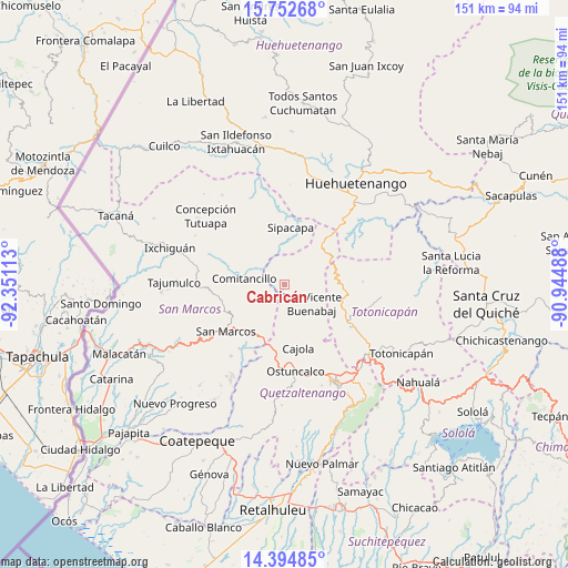
Cabricán GPS coordinates[2]
15° 4' 29.46" North, 91° 38' 52.8" West
| Map corner | latitude | longitude |
|---|---|---|
| Upper-left | 15.75268°, | -92.35113° |
| Center: | 15.07485°, | -91.648° |
| Lower-right: | 14.39485°, | -90.94488° |
| Map W x H: | 151×151 km | = 93.8×93.8mi |
| max Lat: | 17.06606° ⇑29.2% North |
| Cabricán: | 15.07485° |
| min Lat: | ⇓70.8% South 13.9274° |
| min Long | Cabricán | max Long |
| -92.19298° | -91.648° | -88.59444° |
| W 16.8%⇐ | ⇒83.2% E |
Elevation
Elevation of Cabricán is 2617 m = 8586 ft, and this is 1350 m = 4429 ft above average elevation for this country.
| Max E: |
3254 m = 10676 ft | 3.2% |
| Cabricán | 2617 m 8586 ft | |
| Avg. | 1267 m = 4157 ft | |
Min E: |
1 m = 3 ft | 96.8% |
See also: Guatemala elevation on elevation.city.
Geographical zone
Cabricán is located in North Torrid zone (between Equator and Tropic of Cancer). Distance of this Northern Tropic circle is 929.8 km =577.8 mi to North.| Distance of | km | miles | from Cabricán |
|---|---|---|---|
| North Pole | 8330.9 | 5176.6 | to North |
| Arctic Circle | 5725 | 3557.3 | to North |
| Tropic Cancer | 929.8 | 577.8 | to North |
| Equator | 1676.2 | 1041.5 | to South |


Nearby cities:
15 places around Cabricán: (largest is in red/bold)
• Cajolá
17.4 km =10.8 mi,  168°
168°
• Comitancillo
11 km =6.8 mi,  278°
278°
• Huitán
3 km =1.9 mi,  162°
162°
• Palestina de los Altos
16.5 km =10.3 mi,  197°
197°
• Río Blanco
5.7 km =3.5 mi,  223°
223°
• San Antonio Sacatepéquez
15.6 km =9.7 mi, 215°
• San Carlos Sija
14.6 km =9.1 mi,  133°
133°
• San Francisco la Unión
20.3 km =12.6 mi,  145°
145°
• San Lorenzo
10.6 km =6.6 mi,  242°
242°
• San Marcos
20 km =12.4 mi,  231°
231°
• San Miguel Sigüilá
20.3 km =12.6 mi, 169°
• San Pedro Sacatepéquez
17 km =10.6 mi, 225°
• Sibilia
9.4 km =5.8 mi, 163°
• Sipacapa
15.4 km =9.6 mi,  5°
5°
• Tejutla
17.8 km =11.1 mi,  287°
287°
Sources, notices
• [Note1] Compared only with cities in Guatemala existing in our database
• [Src1] Map data: © OpenStreetMap contributors (CC-BY-SA)
• [Src2] Other city data from geonames.org with taken over terms of usage.
• [Src3] Geographical zone / Annual Mean Temperature by Robert A. Rohde @ Wikipedia
