San Luis Ixcán geodata
San Luis Ixcán (Quiché) is a populated place; located in Guatemala in America/Guatemala (GMT-6) time zone. With population of 7,850 people, there are 158 cities with bigger population in this country. Compared to other cities in Guatemala, 93.2% of cities are located further ↓South; 54.9% of cities are located further →East and 83.2% of cities have higher elevation than San Luis Ixcán. Note1


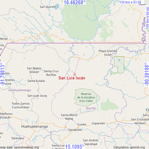
San Luis Ixcán GPS coordinates[2]
15° 47' 13.992" North, 91° 5' 42" West
| Map corner | latitude | longitude |
|---|---|---|
| Upper-left | 16.46268°, | -91.79813° |
| Center: | 15.78722°, | -91.095° |
| Lower-right: | 15.1095°, | -90.39188° |
| Map W x H: | 150.5×150.5 km | = 93.5×93.5mi |
| max Lat: | 17.06606° ⇑6.8% North |
| San Luis Ixcán: | 15.78722° |
| min Lat: | ⇓93.2% South 13.9274° |
| min Long | San Luis Ixcán | max Long |
| -92.19298° | -91.095° | -88.59444° |
| W 45.1%⇐ | ⇒54.9% E |
Elevation
Elevation of San Luis Ixcán is 294 m = 965 ft, and this is 973 m = 3192 ft below average elevation for this country.
| Max E: |
3254 m = 10676 ft | 83.2% |
| Avg. | 1267 m = 4157 ft | |
| San Luis Ixcán | 294 m = 965 ft | |
Min E: |
1 m = 3 ft | 16.8% |
See also: Guatemala elevation on elevation.city.
Geographical zone
San Luis Ixcán is located in North Torrid zone (between Equator and Tropic of Cancer). Distance of this Northern Tropic circle is 850.5 km =528.5 mi to North.| Distance of | km | miles | from San Luis Ixcán |
|---|---|---|---|
| North Pole | 8251.7 | 5127.4 | to North |
| Arctic Circle | 5645.8 | 3508.1 | to North |
| Tropic Cancer | 850.5 | 528.5 | to North |
| Equator | 1755.4 | 1090.8 | to South |


Nearby cities:
15 places around San Luis Ixcán: (largest is in red/bold)
• Aguacatán
54.6 km =33.9 mi,  205°
205°
• Barillas
23.7 km =14.7 mi,  274°
274°
• Chajul
34.2 km =21.3 mi,  169°
169°
• Cunén
50.7 km =31.5 mi, 171°
• Nebaj
42.7 km =26.5 mi,  187°
187°
• Playa Grande
42 km =26.1 mi,  67°
67°
• San Juan Cotzal
39.8 km =24.7 mi, 170°
• San Juan Ixcoy
43 km =26.7 mi,  241°
241°
• San Mateo Ixtatán
41.3 km =25.7 mi,  276°
276°
• San Miguel Acatán
54.6 km =33.9 mi,  260°
260°
• San Rafael La Independencia
48.1 km =29.9 mi, 258°
• San Sebastián Coatán
50.4 km =31.3 mi, 263°
• Santa Eulalia
39.4 km =24.5 mi, 260°
• Soloma
38.6 km =24 mi,  248°
248°
• Uspantán
54.6 km =33.9 mi,  153°
153°
Sources, notices
• [Note1] Compared only with cities in Guatemala existing in our database
• [Src1] Map data: © OpenStreetMap contributors (CC-BY-SA)
• [Src2] Other city data from geonames.org with taken over terms of usage.
• [Src3] Geographical zone / Annual Mean Temperature by Robert A. Rohde @ Wikipedia
