Barillas geodata
Barillas (Huehuetenango) is a seat of a second-order administrative division; located in Guatemala in America/Guatemala (GMT-6) time zone. With population of 14,100 people, there are 88 cities with bigger population in this country. Compared to other cities in Guatemala, 94.1% of cities are located further ↓South; 63.7% of cities are located further →East and 57.8% of cities have lower elevation than Barillas. Note1


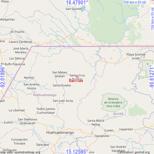
Barillas GPS coordinates[2]
15° 48' 12.996" North, 91° 18' 56.988" West
| Map corner | latitude | longitude |
|---|---|---|
| Upper-left | 16.47901°, | -92.01896° |
| Center: | 15.80361°, | -91.31583° |
| Lower-right: | 15.12595°, | -90.61271° |
| Map W x H: | 150.4×150.4 km | = 93.5×93.5mi |
| max Lat: | 17.06606° ⇑5.9% North |
| Barillas: | 15.80361° |
| min Lat: | ⇓94.1% South 13.9274° |
| min Long | Barillas | max Long |
| -92.19298° | -91.31583° | -88.59444° |
| W 36.3%⇐ | ⇒63.7% E |
Elevation
Elevation of Barillas is 1462 m = 4797 ft, and this is 195 m = 640 ft above average elevation for this country.
| Max E: |
3254 m = 10676 ft | 42.2% |
| Barillas | 1462 m 4797 ft | |
| Avg. | 1267 m = 4157 ft | |
Min E: |
1 m = 3 ft | 57.8% |
See also: Guatemala elevation on elevation.city.
Geographical zone
Barillas is located in North Torrid zone (between Equator and Tropic of Cancer). Distance of this Northern Tropic circle is 848.7 km =527.4 mi to North.| Distance of | km | miles | from Barillas |
|---|---|---|---|
| North Pole | 8249.9 | 5126.2 | to North |
| Arctic Circle | 5644 | 3507 | to North |
| Tropic Cancer | 848.7 | 527.4 | to North |
| Equator | 1757.2 | 1091.9 | to South |


Nearby cities:
15 places around Barillas: (largest is in red/bold)
• Chajul
46.4 km =28.8 mi,  139°
139°
• Concepción Huista
42.4 km =26.3 mi,  241°
241°
• Jacaltenango
45 km =28 mi,  250°
250°
• Nebaj
47.8 km =29.7 mi,  157°
157°
• Nentón
46.9 km =29.1 mi,  269°
269°
• San Juan Cotzal
51 km =31.7 mi, 143°
• San Juan Ixcoy
26.6 km =16.5 mi,  211°
211°
• San Luis Ixcán
23.7 km =14.7 mi,  94°
94°
• San Mateo Ixtatán
17.6 km =10.9 mi,  280°
280°
• San Miguel Acatán
32.1 km =19.9 mi, 249°
• San Rafael La Independencia
26.1 km =16.2 mi, 244°
• San Sebastián Coatán
27.5 km =17.1 mi, 254°
• Santa Eulalia
17.3 km =10.7 mi, 241°
• Soloma
20.2 km =12.6 mi,  217°
217°
• Todos Santos Cuchumatán
45 km =28 mi, 223°
Sources, notices
• [Note1] Compared only with cities in Guatemala existing in our database
• [Src1] Map data: © OpenStreetMap contributors (CC-BY-SA)
• [Src2] Other city data from geonames.org with taken over terms of usage.
• [Src3] Geographical zone / Annual Mean Temperature by Robert A. Rohde @ Wikipedia
