Quezaltepeque geodata
Quezaltepeque (Chiquimula) is a seat of a second-order administrative division; located in Guatemala in America/Guatemala (GMT-6) time zone. With population of 4,126 people, there are 220 cities with bigger population in this country. Compared to other cities in Guatemala, 66.4% of cities are located further ↑North; 95.3% of cities are located further ←West and 68.4% of cities have higher elevation than Quezaltepeque. Note1


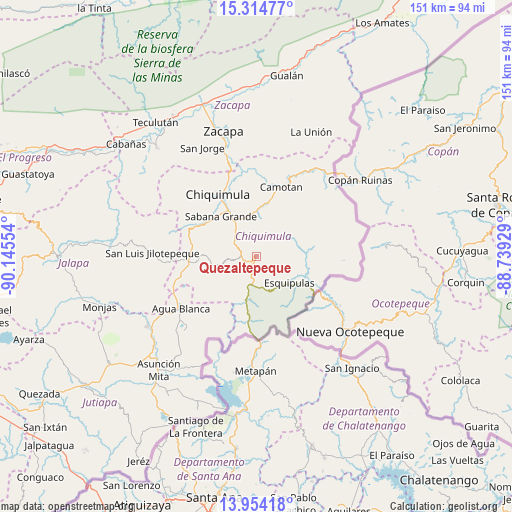
Quezaltepeque GPS coordinates[2]
14° 38' 7.908" North, 89° 26' 32.676" West
| Map corner | latitude | longitude |
|---|---|---|
| Upper-left | 15.31477°, | -90.14554° |
| Center: | 14.63553°, | -89.44241° |
| Lower-right: | 13.95418°, | -88.73929° |
| Map W x H: | 151.3×151.3 km | = 94×94mi |
| max Lat: | 17.06606° ⇑66.4% North |
| Quezaltepeque: | 14.63553° |
| min Lat: | ⇓33.6% South 13.9274° |
| min Long | Quezaltepeque | max Long |
| -92.19298° | -89.44241° | -88.59444° |
| W 95.3%⇐ | ⇒4.7% E |
Elevation
Elevation of Quezaltepeque is 700 m = 2297 ft, and this is 567 m = 1860 ft below average elevation for this country.
| Max E: |
3254 m = 10676 ft | 68.4% |
| Avg. | 1267 m = 4157 ft | |
| Quezaltepeque | 700 m = 2297 ft | |
Min E: |
1 m = 3 ft | 31.6% |
See also: Guatemala elevation on elevation.city.
Geographical zone
Quezaltepeque is located in North Torrid zone (between Equator and Tropic of Cancer). Distance of this Northern Tropic circle is 978.6 km =608.1 mi to North.| Distance of | km | miles | from Quezaltepeque |
|---|---|---|---|
| North Pole | 8379.7 | 5206.9 | to North |
| Arctic Circle | 5773.9 | 3587.7 | to North |
| Tropic Cancer | 978.6 | 608.1 | to North |
| Equator | 1627.3 | 1011.2 | to South |


Nearby cities:
15 places around Quezaltepeque: (largest is in red/bold)
• Agua Blanca
26.9 km =16.7 mi,  235°
235°
• Camotán
21.9 km =13.6 mi,  20°
20°
• Chiquimula
21.4 km =13.3 mi,  328°
328°
• Concepción Las Minas
12.8 km =8 mi,  187°
187°
• Esquipulas
12.5 km =7.8 mi,  128°
128°
• Ipala
18.9 km =11.7 mi,  263°
263°
• Jocotán
21.4 km =13.3 mi, 15°
• Olopa
11.8 km =7.3 mi,  57°
57°
• San Jacinto
7.1 km =4.4 mi,  299°
299°
• San Jorge
36.4 km =22.6 mi,  335°
335°
• San José La Arada
17.6 km =10.9 mi, 300°
• San Juan Ermita
14.4 km =8.9 mi,  5°
5°
• San Luis Jilotepeque
31.3 km =19.4 mi,  272°
272°
• San Manuel Chaparrón
37.3 km =23.2 mi,  249°
249°
• Zacapa
38.6 km =24 mi,  345°
345°
Sources, notices
• [Note1] Compared only with cities in Guatemala existing in our database
• [Src1] Map data: © OpenStreetMap contributors (CC-BY-SA)
• [Src2] Other city data from geonames.org with taken over terms of usage.
• [Src3] Geographical zone / Annual Mean Temperature by Robert A. Rohde @ Wikipedia
