San Jacinto geodata
San Jacinto (Chiquimula) is a populated place; located in Guatemala in America/Guatemala (GMT-6) time zone. With population of 1,519 people, there are 297 cities with bigger population in this country. Compared to other cities in Guatemala, 63.4% of cities are located further ↑North; 94.7% of cities are located further ←West and 72.3% of cities have higher elevation than San Jacinto. Note1


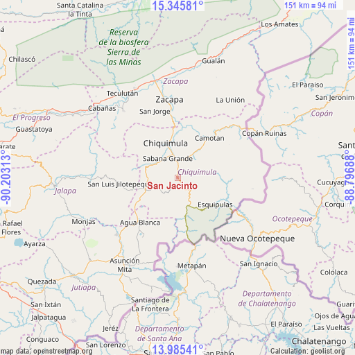
San Jacinto GPS coordinates[2]
14° 40' 0.012" North, 89° 30' 0" West
| Map corner | latitude | longitude |
|---|---|---|
| Upper-left | 15.34581°, | -90.20313° |
| Center: | 14.66667°, | -89.5° |
| Lower-right: | 13.98541°, | -88.79688° |
| Map W x H: | 151.3×151.3 km | = 94×94mi |
| max Lat: | 17.06606° ⇑63.4% North |
| San Jacinto: | 14.66667° |
| min Lat: | ⇓36.6% South 13.9274° |
| min Long | San Jacinto | max Long |
| -92.19298° | -89.5° | -88.59444° |
| W 94.7%⇐ | ⇒5.3% E |
Elevation
Elevation of San Jacinto is 534 m = 1752 ft, and this is 733 m = 2405 ft below average elevation for this country.
| Max E: |
3254 m = 10676 ft | 72.3% |
| Avg. | 1267 m = 4157 ft | |
| San Jacinto | 534 m = 1752 ft | |
Min E: |
1 m = 3 ft | 27.7% |
See also: Guatemala elevation on elevation.city.
Geographical zone
San Jacinto is located in North Torrid zone (between Equator and Tropic of Cancer). Distance of this Northern Tropic circle is 975.1 km =605.9 mi to North.| Distance of | km | miles | from San Jacinto |
|---|---|---|---|
| North Pole | 8376.3 | 5204.8 | to North |
| Arctic Circle | 5770.4 | 3585.6 | to North |
| Tropic Cancer | 975.1 | 605.9 | to North |
| Equator | 1630.8 | 1013.3 | to South |


Nearby cities:
15 places around San Jacinto: (largest is in red/bold)
• Agua Blanca
24.6 km =15.3 mi,  221°
221°
• Camotán
21.9 km =13.6 mi,  38°
38°
• Chiquimula
15.6 km =9.7 mi,  341°
341°
• Concepción Las Minas
16.8 km =10.4 mi,  164°
164°
• Esquipulas
19.5 km =12.1 mi,  125°
125°
• Ipala
13.7 km =8.5 mi,  246°
246°
• Jocotán
20.8 km =12.9 mi,  34°
34°
• Olopa
16.4 km =10.2 mi,  79°
79°
• Quezaltepeque
7.1 km =4.4 mi,  119°
119°
• San Diego
33.1 km =20.6 mi,  293°
293°
• San Jorge
31 km =19.3 mi, 343°
• San José La Arada
10.5 km =6.5 mi,  301°
301°
• San Juan Ermita
13.2 km =8.2 mi, 34°
• San Luis Jilotepeque
25.2 km =15.7 mi,  265°
265°
• San Manuel Chaparrón
33.2 km =20.6 mi,  239°
239°
Sources, notices
• [Note1] Compared only with cities in Guatemala existing in our database
• [Src1] Map data: © OpenStreetMap contributors (CC-BY-SA)
• [Src2] Other city data from geonames.org with taken over terms of usage.
• [Src3] Geographical zone / Annual Mean Temperature by Robert A. Rohde @ Wikipedia
