Esquipulas geodata
Esquipulas (Chiquimula) is a seat of a second-order administrative division; located in Guatemala in America/Guatemala (GMT-6) time zone. With population of 20,674 people, there are 52 cities with bigger population in this country. Compared to other cities in Guatemala, 74.9% of cities are located further ↑North; 97.6% of cities are located further ←West and 58.4% of cities have higher elevation than Esquipulas. Note1


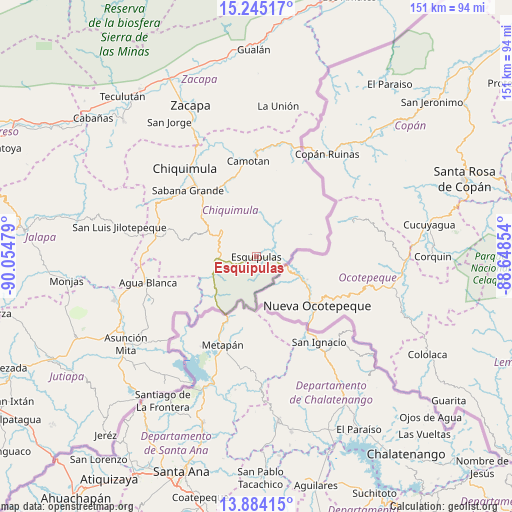
Esquipulas GPS coordinates[2]
14° 33' 56.556" North, 89° 21' 5.976" West
| Map corner | latitude | longitude |
|---|---|---|
| Upper-left | 15.24517°, | -90.05479° |
| Center: | 14.56571°, | -89.35166° |
| Lower-right: | 13.88415°, | -88.64854° |
| Map W x H: | 151.3×151.3 km | = 94×94mi |
| max Lat: | 17.06606° ⇑74.9% North |
| Esquipulas: | 14.56571° |
| min Lat: | ⇓25.1% South 13.9274° |
| min Long | Esquipulas | max Long |
| -92.19298° | -89.35166° | -88.59444° |
| W 97.6%⇐ | ⇒2.4% E |
Elevation
Elevation of Esquipulas is 977 m = 3205 ft, and this is 290 m = 951 ft below average elevation for this country.
| Max E: |
3254 m = 10676 ft | 58.4% |
| Avg. | 1267 m = 4157 ft | |
| Esquipulas | 977 m = 3205 ft | |
Min E: |
1 m = 3 ft | 41.6% |
See also: Guatemala elevation on elevation.city.
Geographical zone
Esquipulas is located in North Torrid zone (between Equator and Tropic of Cancer). Distance of this Northern Tropic circle is 986.4 km =612.9 mi to North.| Distance of | km | miles | from Esquipulas |
|---|---|---|---|
| North Pole | 8387.5 | 5211.7 | to North |
| Arctic Circle | 5781.6 | 3592.5 | to North |
| Tropic Cancer | 986.4 | 612.9 | to North |
| Equator | 1619.6 | 1006.4 | to South |


Nearby cities:
15 places around Esquipulas: (largest is in red/bold)
• Agua Blanca
32.9 km =20.4 mi,  257°
257°
• Camotán
28.4 km =17.6 mi,  355°
355°
• Chiquimula
33.4 km =20.8 mi,  321°
321°
• Concepción Las Minas
12.4 km =7.7 mi,  246°
246°
• Ipala
29.1 km =18.1 mi,  281°
281°
• Jocotán
28.7 km =17.8 mi,  351°
351°
• La Unión
45.1 km =28 mi,  8°
8°
• Olopa
14.1 km =8.8 mi,  0°
0°
• Quezaltepeque
12.5 km =7.8 mi,  308°
308°
• San Jacinto
19.5 km =12.1 mi, 305°
• San José La Arada
30 km =18.6 mi,  303°
303°
• San Juan Ermita
23.7 km =14.7 mi,  339°
339°
• San Luis Jilotepeque
42.1 km =26.2 mi, 282°
• San Manuel Chaparrón
45 km =28 mi, 263°
• Santa Catarina Mita
44.8 km =27.8 mi, 253°
Sources, notices
• [Note1] Compared only with cities in Guatemala existing in our database
• [Src1] Map data: © OpenStreetMap contributors (CC-BY-SA)
• [Src2] Other city data from geonames.org with taken over terms of usage.
• [Src3] Geographical zone / Annual Mean Temperature by Robert A. Rohde @ Wikipedia
