Várpalota geodata
Várpalota (Veszprém) is a seat of a second-order administrative division; located in Hungary in Europe/Budapest (GMT+2) time zone. With population of 21,299 people, there are 80 cities with bigger population in this country. Compared to other cities in Hungary, 61.9% of cities are located further ↑North; 83.8% of cities are located further →East and 80.2% of cities have lower elevation than Várpalota. Note1


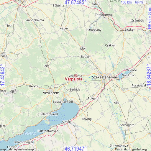
Várpalota GPS coordinates[2]
47° 11' 57.696" North, 18° 8' 22.344" East
| Map corner | latitude | longitude |
|---|---|---|
| Upper-left | 47.67495°, | 17.43642° |
| Center: | 47.19936°, | 18.13954° |
| Lower-right: | 46.71947°, | 18.84267° |
| Map W x H: | 106.2×106.2 km | = 66×66mi |
| max Lat: | 48.46667° ⇑61.9% North |
| Várpalota: | 47.19936° |
| min Lat: | ⇓38.1% South 45.79108° |
| min Long | Várpalota | max Long |
| 16.27358° | 18.13954° | 22.68096° |
| W 16.2%⇐ | ⇒83.8% E |
Elevation
Elevation of Várpalota is 158 m = 518 ft, and this is 28.3 m = 93 ft above average elevation for this country.
| Max E: |
444 m = 1457 ft | 19.8% |
| Várpalota | 158 m 518 ft | |
| Avg. | 129.7 m = 426 ft | |
Min E: |
71 m = 233 ft | 80.2% |
See also: Hungary elevation on elevation.city.
Geographical zone
Várpalota is located in North temperate zone (between Tropic of Cancer and the Arctic Circle). Distance of this North polar circle is 2153.1 km =1337.9 mi to North.| Distance of | km | miles | from Várpalota |
|---|---|---|---|
| North Pole | 4759 | 2957.1 | to North |
| Arctic Circle | 2153.1 | 1337.9 | to North |
| Tropic Cancer | 2642.2 | 1641.8 | to South |
| Equator | 5248.1 | 3261 | to South |


Nearby cities:
15 places around Várpalota: (largest is in red/bold)
• Bakonycsernye
14.7 km =9.1 mi,  340°
340°
• Balatonalmádi
20.3 km =12.6 mi,  206°
206°
• Balatonkenese
17.9 km =11.1 mi,  187°
187°
• Berhida
9.8 km =6.1 mi,  184°
184°
• Bodajk
15.5 km =9.6 mi,  27°
27°
• Csetény
17.3 km =10.7 mi,  319°
319°
• Fehérvárcsurgó
14.1 km =8.8 mi,  42°
42°
• Hajmáskér
10.9 km =6.8 mi,  236°
236°
• Kincsesbánya
12.7 km =7.9 mi,  55°
55°
• Litér
15 km =9.3 mi,  223°
223°
• Polgárdi
19.7 km =12.2 mi,  141°
141°
• Pétfürdő
4 km =2.5 mi, 205°
• Szabadbattyán
19.5 km =12.1 mi,  117°
117°
• Sárszentmihály
15.9 km =9.9 mi,  108°
108°
• Ősi
6.9 km =4.3 mi,  147°
147°
Sources, notices
• [Note1] Compared only with cities in Hungary existing in our database
• [Src1] Map data: © OpenStreetMap contributors (CC-BY-SA)
• [Src2] Other city data from geonames.org with taken over terms of usage.
• [Src3] Geographical zone / Annual Mean Temperature by Robert A. Rohde @ Wikipedia
