Bakonycsernye geodata
Bakonycsernye (Fejér) is a populated place; located in Hungary in Europe/Budapest (GMT+2) time zone. With population of 3,177 people, there are 463 cities with bigger population in this country. Compared to other cities in Hungary, 55.1% of cities are located further ↑North; 85% of cities are located further →East and 93.6% of cities have lower elevation than Bakonycsernye. Note1


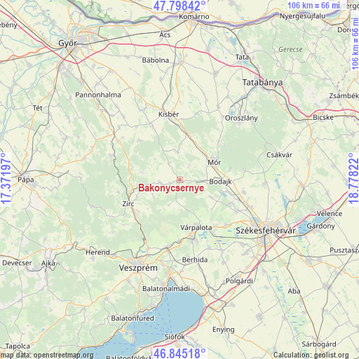
Bakonycsernye GPS coordinates[2]
47° 19' 26.22" North, 18° 4' 30.324" East
| Map corner | latitude | longitude |
|---|---|---|
| Upper-left | 47.79842°, | 17.37197° |
| Center: | 47.32395°, | 18.07509° |
| Lower-right: | 46.84518°, | 18.77822° |
| Map W x H: | 106×106 km | = 65.9×65.9mi |
| max Lat: | 48.46667° ⇑55.1% North |
| Bakonycsernye: | 47.32395° |
| min Lat: | ⇓44.9% South 45.79108° |
| min Long | Bakonycsernye | max Long |
| 16.27358° | 18.07509° | 22.68096° |
| W 15%⇐ | ⇒85% E |
Elevation
Elevation of Bakonycsernye is 210 m = 689 ft, and this is 80.3 m = 263 ft above average elevation for this country.
| Max E: |
444 m = 1457 ft | 6.4% |
| Bakonycsernye | 210 m 689 ft | |
| Avg. | 129.7 m = 426 ft | |
Min E: |
71 m = 233 ft | 93.6% |
See also: Hungary elevation on elevation.city.
Geographical zone
Bakonycsernye is located in North temperate zone (between Tropic of Cancer and the Arctic Circle). Distance of this North polar circle is 2139.2 km =1329.2 mi to North.| Distance of | km | miles | from Bakonycsernye |
|---|---|---|---|
| North Pole | 4745.1 | 2948.5 | to North |
| Arctic Circle | 2139.2 | 1329.2 | to North |
| Tropic Cancer | 2656 | 1650.4 | to South |
| Equator | 5261.9 | 3269.6 | to South |


Nearby cities:
15 places around Bakonycsernye: (largest is in red/bold)
• Bakonyszentlászló
21.7 km =13.5 mi,  289°
289°
• Bodajk
11.9 km =7.4 mi,  90°
90°
• Bokod
22.7 km =14.1 mi,  34°
34°
• Csetény
6.3 km =3.9 mi,  264°
264°
• Császár
20 km =12.4 mi,  14°
14°
• Fehérvárcsurgó
14.7 km =9.1 mi,  103°
103°
• Hajmáskér
20.3 km =12.6 mi,  191°
191°
• Kincsesbánya
16.7 km =10.4 mi,  113°
113°
• Kisbér
20.1 km =12.5 mi,  351°
351°
• Mór
11.4 km =7.1 mi,  58°
58°
• Pusztavám
16.4 km =10.2 mi,  44°
44°
• Pétfürdő
17.8 km =11.1 mi,  169°
169°
• Várpalota
14.7 km =9.1 mi,  160°
160°
• Zirc
16.6 km =10.3 mi,  246°
246°
• Ősi
21.4 km =13.3 mi, 156°
Sources, notices
• [Note1] Compared only with cities in Hungary existing in our database
• [Src1] Map data: © OpenStreetMap contributors (CC-BY-SA)
• [Src2] Other city data from geonames.org with taken over terms of usage.
• [Src3] Geographical zone / Annual Mean Temperature by Robert A. Rohde @ Wikipedia
