Pápa geodata
Pápa (Veszprém) is a seat of a second-order administrative division; located in Hungary in Europe/Budapest (GMT+2) time zone. With population of 32,990 people, there are 50 cities with bigger population in this country. Compared to other cities in Hungary, 54.8% of cities are located further ↑North; 91.7% of cities are located further →East and 78.7% of cities have lower elevation than Pápa. Note1


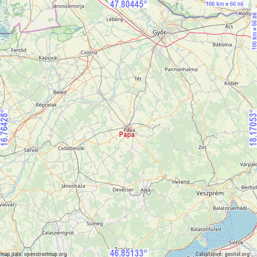
Pápa GPS coordinates[2]
47° 19' 48.144" North, 17° 28' 2.64" East
| Map corner | latitude | longitude |
|---|---|---|
| Upper-left | 47.80445°, | 16.76428° |
| Center: | 47.33004°, | 17.4674° |
| Lower-right: | 46.85133°, | 18.17053° |
| Map W x H: | 106×106 km | = 65.9×65.9mi |
| max Lat: | 48.46667° ⇑54.8% North |
| Pápa: | 47.33004° |
| min Lat: | ⇓45.2% South 45.79108° |
| min Long | Pápa | max Long |
| 16.27358° | 17.4674° | 22.68096° |
| W 8.3%⇐ | ⇒91.7% E |
Elevation
Elevation of Pápa is 154 m = 505 ft, and this is 24.3 m = 80 ft above average elevation for this country.
| Max E: |
444 m = 1457 ft | 21.3% |
| Pápa | 154 m 505 ft | |
| Avg. | 129.7 m = 426 ft | |
Min E: |
71 m = 233 ft | 78.7% |
See also: Hungary elevation on elevation.city.
Geographical zone
Pápa is located in North temperate zone (between Tropic of Cancer and the Arctic Circle). Distance of this North polar circle is 2138.6 km =1328.9 mi to North.| Distance of | km | miles | from Pápa |
|---|---|---|---|
| North Pole | 4744.5 | 2948.1 | to North |
| Arctic Circle | 2138.6 | 1328.9 | to North |
| Tropic Cancer | 2656.7 | 1650.8 | to South |
| Equator | 5262.6 | 3270 | to South |


Nearby cities:
15 places around Pápa: (largest is in red/bold)
• Ajka
26.3 km =16.3 mi,  164°
164°
• Bakonyszentlászló
26.1 km =16.2 mi,  75°
75°
• Beled
32 km =19.9 mi,  298°
298°
• Celldömölk
25.3 km =15.7 mi,  251°
251°
• Devecser
25.3 km =15.7 mi,  185°
185°
• Győrszemere
25.8 km =16 mi,  16°
16°
• Herend
30.6 km =19 mi,  135°
135°
• Jánosháza
32.7 km =20.3 mi,  224°
224°
• Pannonhalma
32.6 km =20.3 mi,  41°
41°
• Rábacsécsény
28.7 km =17.8 mi,  353°
353°
• Rábaszentmihály
27.6 km =17.1 mi, 354°
• Szany
19.3 km =12 mi,  320°
320°
• Tét
21.3 km =13.2 mi,  8°
8°
• Zirc
31.5 km =19.6 mi,  103°
103°
• Úrkút
30.3 km =18.8 mi,  153°
153°
Sources, notices
• [Note1] Compared only with cities in Hungary existing in our database
• [Src1] Map data: © OpenStreetMap contributors (CC-BY-SA)
• [Src2] Other city data from geonames.org with taken over terms of usage.
• [Src3] Geographical zone / Annual Mean Temperature by Robert A. Rohde @ Wikipedia
