Tázlár geodata
Tázlár (Bács-Kiskun) is a populated place; located in Hungary in Europe/Budapest (GMT+2) time zone. With population of 1,984 people, there are 796 cities with bigger population in this country. Compared to other cities in Hungary, 84.5% of cities are located further ↑North; 50.1% of cities are located further ←West and 52.5% of cities have higher elevation than Tázlár. Note1


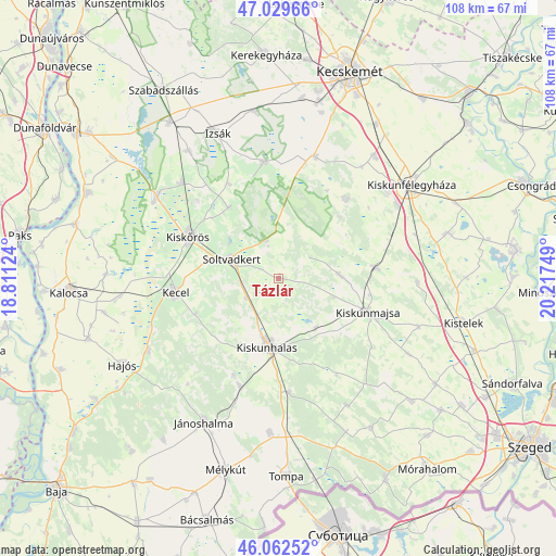
Tázlár GPS coordinates[2]
46° 32' 53.664" North, 19° 30' 51.696" East
| Map corner | latitude | longitude |
|---|---|---|
| Upper-left | 47.02966°, | 18.81124° |
| Center: | 46.54824°, | 19.51436° |
| Lower-right: | 46.06252°, | 20.21749° |
| Map W x H: | 107.5×107.5 km | = 66.8×66.8mi |
| max Lat: | 48.46667° ⇑84.5% North |
| Tázlár: | 46.54824° |
| min Lat: | ⇓15.5% South 45.79108° |
| min Long | Tázlár | max Long |
| 16.27358° | 19.51436° | 22.68096° |
| W 50.1%⇐ | ⇒49.9% E |
Elevation
Elevation of Tázlár is 114 m = 374 ft, and this is 15.7 m = 52 ft below average elevation for this country.
| Max E: |
444 m = 1457 ft | 52.5% |
| Avg. | 129.7 m = 426 ft | |
| Tázlár | 114 m = 374 ft | |
Min E: |
71 m = 233 ft | 47.5% |
See also: Hungary elevation on elevation.city.
Geographical zone
Tázlár is located in North temperate zone (between Tropic of Cancer and the Arctic Circle). Distance of this North polar circle is 2225.5 km =1382.9 mi to North.| Distance of | km | miles | from Tázlár |
|---|---|---|---|
| North Pole | 4831.4 | 3002.1 | to North |
| Arctic Circle | 2225.5 | 1382.9 | to North |
| Tropic Cancer | 2569.8 | 1596.8 | to South |
| Equator | 5175.7 | 3216 | to South |


Nearby cities:
15 places around Tázlár: (largest is in red/bold)
• Akasztó
28.6 km =17.8 mi,  303°
303°
• Bugac
20 km =12.4 mi,  39°
39°
• Csengele
26.7 km =16.6 mi,  91°
91°
• Csengőd
26.4 km =16.4 mi,  314°
314°
• Császártöltés
29 km =18 mi,  240°
240°
• Fülöpjakab
26.7 km =16.6 mi, 36°
• Jászszentlászló
18.9 km =11.7 mi,  83°
83°
• Kecel
20.2 km =12.6 mi,  262°
262°
• Kiskunhalas
12.9 km =8 mi,  190°
190°
• Kiskunmajsa
18.4 km =11.4 mi,  110°
110°
• Kiskőrös
19.3 km =12 mi,  294°
294°
• Kunfehértó
22.2 km =13.8 mi,  200°
200°
• Orgovány
22.8 km =14.2 mi,  351°
351°
• Soltvadkert
9.8 km =6.1 mi, 290°
• Szank
11.3 km =7 mi, 84°
Sources, notices
• [Note1] Compared only with cities in Hungary existing in our database
• [Src1] Map data: © OpenStreetMap contributors (CC-BY-SA)
• [Src2] Other city data from geonames.org with taken over terms of usage.
• [Src3] Geographical zone / Annual Mean Temperature by Robert A. Rohde @ Wikipedia
