Lauke geodata
Lauke (Aceh) is a seat of a third-order administrative division; located in Indonesia in Asia/Jakarta (GMT+7) time zone. In our database, there are 407 cities with bigger population. Compared to other cities in Indonesia, 97.6% of cities are located further ↓South; 99.6% of cities are located further →East and 54.8% of cities have higher elevation than Lauke. Note1


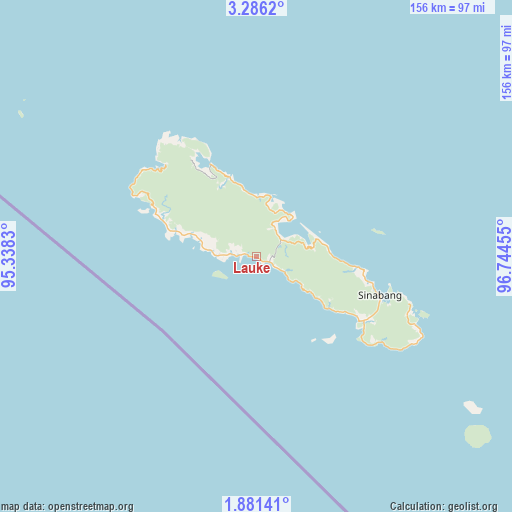
Lauke GPS coordinates[2]
2° 35' 2.4" North, 96° 2' 29.112" East
| Map corner | latitude | longitude |
|---|---|---|
| Upper-left | 3.2862°, | 95.3383° |
| Center: | 2.584°, | 96.04142° |
| Lower-right: | 1.88141°, | 96.74455° |
| Map W x H: | 156.2×156.2 km | = 97.1×97.1mi |
| max Lat: | 5.88969° ⇑2.4% North |
| Lauke: | 2.584° |
| min Lat: | ⇓97.6% South -10.934° |
| min Long | Lauke | max Long |
| 95.1345° | 96.04142° | 140.9419° |
| W 0.4%⇐ | ⇒99.6% E |
Elevation
Elevation of Lauke is 86 m = 282 ft, and this is 143.7 m = 471 ft below average elevation for this country.
| Max E: |
3185 m = 10449 ft | 54.8% |
| Avg. | 229.7 m = 754 ft | |
| Lauke | 86 m = 282 ft | |
Min E: |
-1 m = -3 ft | 45.2% |
See also: Indonesia elevation on elevation.city.
Geographical zone
Lauke is located in North Torrid zone (between Equator and Tropic of Cancer). Distance of Equator is 287.3 km =178.5 mi to South.| Distance of | km | miles | from Lauke |
|---|---|---|---|
| North Pole | 9719.7 | 6039.5 | to North |
| Arctic Circle | 7113.9 | 4420.4 | to North |
| Tropic Cancer | 2318.6 | 1440.7 | to North |
| Equator | 287.3 | 178.5 | to South |


Nearby cities:
15 places around Lauke: (largest is in red/bold)
• Blangpidie
155.9 km =96.9 mi,  34°
34°
• Kota Trieng
152.2 km =94.6 mi,  42°
42°
• Labuhan Bajau
50.3 km =31.3 mi,  113°
113°
• Luan Balu
32.9 km =20.4 mi,  101°
101°
• Meukek
150.6 km =93.6 mi,  48°
48°
• Peuleumat
151.9 km =94.4 mi, 46°
• Pulo Batal
138.4 km =86 mi, 106°
• Samadua
147 km =91.3 mi,  55°
55°
• Sawang
148.8 km =92.5 mi, 52°
• Sibigo
31.7 km =19.7 mi,  333°
333°
• Sinabang
39.3 km =24.4 mi, 107°
• Suak Bakung
154.2 km =95.8 mi,  72°
72°
• Susoh
153.5 km =95.4 mi, 34°
• Tangantangancut
154.7 km =96.1 mi, 37°
• Terbangan
153.6 km =95.4 mi, 62°
Sources, notices
• [Note1] Compared only with cities in Indonesia existing in our database
• [Src1] Map data: © OpenStreetMap contributors (CC-BY-SA)
• [Src2] Other city data from geonames.org with taken over terms of usage.
• [Src3] Geographical zone / Annual Mean Temperature by Robert A. Rohde @ Wikipedia
