Luan Balu geodata
Luan Balu (Aceh) is a seat of a third-order administrative division; located in Indonesia in Asia/Jakarta (GMT+7) time zone. In our database, there are 407 cities with bigger population. Compared to other cities in Indonesia, 97.6% of cities are located further ↓South; 99.5% of cities are located further →East and 68.9% of cities have higher elevation than Luan Balu. Note1


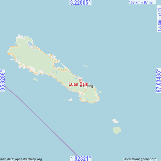
Luan Balu GPS coordinates[2]
2° 31' 32.952" North, 96° 19' 54.192" East
| Map corner | latitude | longitude |
|---|---|---|
| Upper-left | 3.22805°, | 95.6286° |
| Center: | 2.52582°, | 96.33172° |
| Lower-right: | 1.82321°, | 97.03485° |
| Map W x H: | 156.2×156.2 km | = 97.1×97.1mi |
| max Lat: | 5.88969° ⇑2.4% North |
| Luan Balu: | 2.52582° |
| min Lat: | ⇓97.6% South -10.934° |
| min Long | Luan Balu | max Long |
| 95.1345° | 96.33172° | 140.9419° |
| W 0.5%⇐ | ⇒99.5% E |
Elevation
Elevation of Luan Balu is 34 m = 112 ft, and this is 195.7 m = 642 ft below average elevation for this country.
| Max E: |
3185 m = 10449 ft | 68.9% |
| Avg. | 229.7 m = 754 ft | |
| Luan Balu | 34 m = 112 ft | |
Min E: |
-1 m = -3 ft | 31.1% |
See also: Indonesia elevation on elevation.city.
Geographical zone
Luan Balu is located in North Torrid zone (between Equator and Tropic of Cancer). Distance of Equator is 280.8 km =174.5 mi to South.| Distance of | km | miles | from Luan Balu |
|---|---|---|---|
| North Pole | 9726.2 | 6043.6 | to North |
| Arctic Circle | 7120.3 | 4424.3 | to North |
| Tropic Cancer | 2325.1 | 1444.7 | to North |
| Equator | 280.8 | 174.5 | to South |


Nearby cities:
15 places around Luan Balu: (largest is in red/bold)
• Bakungan
135.3 km =84.1 mi,  70°
70°
• Kota Trieng
138.3 km =85.9 mi,  30°
30°
• Labuhan Bajau
19.5 km =12.1 mi,  135°
135°
• Lauke
32.9 km =20.4 mi,  281°
281°
• Meukek
133.2 km =82.8 mi,  37°
37°
• Paya Dapur
142.6 km =88.6 mi,  57°
57°
• Peuleumat
135.7 km =84.3 mi, 34°
• Pulo Batal
105.7 km =65.7 mi,  108°
108°
• Pulo Ie
141.4 km =87.9 mi,  53°
53°
• Samadua
126.4 km =78.5 mi, 44°
• Sawang
129.7 km =80.6 mi, 41°
• Sibigo
58.1 km =36.1 mi,  306°
306°
• Sinabang
7.4 km =4.6 mi,  133°
133°
• Suak Bakung
126.5 km =78.6 mi, 65°
• Terbangan
129.5 km =80.5 mi, 53°
Sources, notices
• [Note1] Compared only with cities in Indonesia existing in our database
• [Src1] Map data: © OpenStreetMap contributors (CC-BY-SA)
• [Src2] Other city data from geonames.org with taken over terms of usage.
• [Src3] Geographical zone / Annual Mean Temperature by Robert A. Rohde @ Wikipedia
