Serpong geodata
Serpong (West Java) is a populated place; located in Indonesia in Asia/Jakarta (GMT+7) time zone. With population of 80,193 people, there are 160 cities with bigger population in this country. Compared to other cities in Indonesia, 86.6% of cities are located further ↓South; 86.8% of cities are located further →East and 62.8% of cities have higher elevation than Serpong. Note1


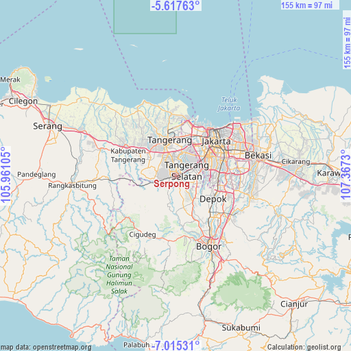
Serpong GPS coordinates[2]
6° 19' 0.984" South, 106° 39' 51.012" East
| Map corner | latitude | longitude |
|---|---|---|
| Upper-left | -5.61763°, | 105.96105° |
| Center: | -6.31694°, | 106.66417° |
| Lower-right: | -7.01531°, | 107.3673° |
| Map W x H: | 155.4×155.4 km | = 96.6×96.6mi |
| max Lat: | 5.88969° ⇑13.4% North |
| Serpong: | -6.31694° |
| min Lat: | ⇓86.6% South -10.934° |
| min Long | Serpong | max Long |
| 95.1345° | 106.66417° | 140.9419° |
| W 13.2%⇐ | ⇒86.8% E |
Elevation
Elevation of Serpong is 49 m = 161 ft, and this is 180.7 m = 593 ft below average elevation for this country.
| Max E: |
3185 m = 10449 ft | 62.8% |
| Avg. | 229.7 m = 754 ft | |
| Serpong | 49 m = 161 ft | |
Min E: |
-1 m = -3 ft | 37.2% |
See also: Serpong elevation on elevation.city.
Geographical zone
Serpong is located in South Torrid zone (between Equator and Tropic of Capricorn). Distance of Equator is 702.4 km =436.5 mi to North.| Distance of | km | miles | from Serpong |
|---|---|---|---|
| Equator | 702.4 | 436.5 | to North |
| Tropic Capricorn | 1903.5 | 1182.8 | to South |
| Antarctic Circle | 6698.8 | 4162.4 | to South |
| South Pole | 9304.7 | 5781.7 | to South |


Nearby cities:
15 places around Serpong: (largest is in red/bold)
• Ciampea
26.7 km =16.6 mi,  171°
171°
• Cikupa
19.4 km =12.1 mi,  297°
297°
• Ciputat
9.5 km =5.9 mi,  21°
21°
• Curug
13.2 km =8.2 mi, 295°
• Depok
19.4 km =12.1 mi,  118°
118°
• Jakarta
23 km =14.3 mi,  60°
60°
• Pamulang
8.7 km =5.4 mi,  109°
109°
• Parung
13.9 km =8.6 mi,  146°
146°
• Pasarkemis
22 km =13.7 mi,  317°
317°
• Sawangan
15.5 km =9.6 mi,  128°
128°
• Sepatan
24.1 km =15 mi,  335°
335°
• South Tangerang
6.7 km =4.2 mi, 62°
• Tangerang
15.9 km =9.9 mi,  346°
346°
• Teluknaga
24.4 km =15.2 mi, 353°
• Tigaraksa
19.3 km =12 mi, 300°
Sources, notices
• [Note1] Compared only with cities in Indonesia existing in our database
• [Src1] Map data: © OpenStreetMap contributors (CC-BY-SA)
• [Src2] Other city data from geonames.org with taken over terms of usage.
• [Src3] Geographical zone / Annual Mean Temperature by Robert A. Rohde @ Wikipedia
