Sawoi geodata
Sawoi (Papua) is a seat of a third-order administrative division; located in Indonesia in Asia/Jayapura (GMT+9) time zone. In our database, there are 407 cities with bigger population. Compared to other cities in Indonesia, 91.9% of cities are located further ↓South; 99.9% of cities are located further ←West and 53.7% of cities have higher elevation than Sawoi. Note1


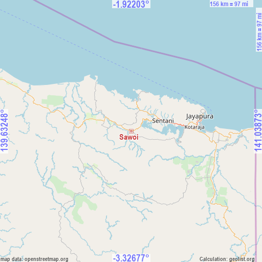
Sawoi GPS coordinates[2]
2° 37' 28.56" South, 140° 20' 8.16" East
| Map corner | latitude | longitude |
|---|---|---|
| Upper-left | -1.92203°, | 139.63248° |
| Center: | -2.6246°, | 140.3356° |
| Lower-right: | -3.32677°, | 141.03873° |
| Map W x H: | 156.2×156.2 km | = 97.1×97.1mi |
| max Lat: | 5.88969° ⇑8.1% North |
| Sawoi: | -2.6246° |
| min Lat: | ⇓91.9% South -10.934° |
| min Long | Sawoi | max Long |
| 95.1345° | 140.3356° | 140.9419° |
| W 99.9%⇐ | ⇒0.099999999999994% E |
Elevation
Elevation of Sawoi is 90 m = 295 ft, and this is 139.7 m = 458 ft below average elevation for this country.
| Max E: |
3185 m = 10449 ft | 53.7% |
| Avg. | 229.7 m = 754 ft | |
| Sawoi | 90 m = 295 ft | |
Min E: |
-1 m = -3 ft | 46.3% |
See also: Indonesia elevation on elevation.city.
Geographical zone
Sawoi is located in South Torrid zone (between Equator and Tropic of Capricorn). Distance of Equator is 291.8 km =181.3 mi to North.| Distance of | km | miles | from Sawoi |
|---|---|---|---|
| Equator | 291.8 | 181.3 | to North |
| Tropic Capricorn | 2314.1 | 1437.9 | to South |
| Antarctic Circle | 7109.3 | 4417.5 | to South |
| South Pole | 9715.2 | 6036.7 | to South |


Nearby cities:
15 places around Sawoi: (largest is in red/bold)
• Abepura
33.1 km =20.6 mi,  84°
84°
• Armopa
84.1 km =52.3 mi,  292°
292°
• Arso
56.9 km =35.4 mi,  122°
122°
• Banda
91.3 km =56.7 mi,  132°
132°
• Betaf
133 km =82.6 mi,  295°
295°
• Demta
36.2 km =22.5 mi,  324°
324°
• Depapre
15.8 km =9.8 mi,  14°
14°
• Elelim
144.1 km =89.5 mi,  208°
208°
• Genyem
21.3 km =13.2 mi,  283°
283°
• Guay
59.9 km =37.2 mi, 283°
• Jayapura
43.7 km =27.2 mi, 76°
• Sengge
103.7 km =64.4 mi,  151°
151°
• Sentani
20.6 km =12.8 mi,  72°
72°
• Ubrub
135.3 km =84.1 mi, 153°
• Waris
81.8 km =50.8 mi, 131°
Sources, notices
• [Note1] Compared only with cities in Indonesia existing in our database
• [Src1] Map data: © OpenStreetMap contributors (CC-BY-SA)
• [Src2] Other city data from geonames.org with taken over terms of usage.
• [Src3] Geographical zone / Annual Mean Temperature by Robert A. Rohde @ Wikipedia
