Tanjungbalai geodata
Tanjungbalai (North Sumatra) is a populated place; located in Indonesia in Asia/Jakarta (GMT+7) time zone. With population of 142,506 people, there are 83 cities with bigger population in this country. Compared to other cities in Indonesia, 98% of cities are located further ↓South; 97.5% of cities are located further →East and 99.1% of cities have higher elevation than Tanjungbalai. Note1


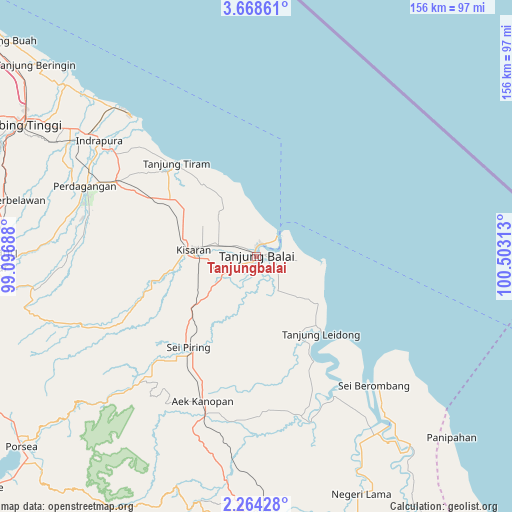
Tanjungbalai GPS coordinates[2]
2° 58' 0.012" North, 99° 48' 0" East
| Map corner | latitude | longitude |
|---|---|---|
| Upper-left | 3.66861°, | 99.09688° |
| Center: | 2.96667°, | 99.8° |
| Lower-right: | 2.26428°, | 100.50313° |
| Map W x H: | 156.1×156.2 km | = 97×97.1mi |
| max Lat: | 5.88969° ⇑2% North |
| Tanjungbalai: | 2.96667° |
| min Lat: | ⇓98% South -10.934° |
| min Long | Tanjungbalai | max Long |
| 95.1345° | 99.8° | 140.9419° |
| W 2.5%⇐ | ⇒97.5% E |
Elevation
Elevation of Tanjungbalai is 4 m = 13 ft, and this is 225.7 m = 740 ft below average elevation for this country.
| Max E: |
3185 m = 10449 ft | 99.1% |
| Avg. | 229.7 m = 754 ft | |
| Tanjungbalai | 4 m = 13 ft | |
Min E: |
-1 m = -3 ft | 0.9% |
See also: Tanjungbalai elevation on elevation.city.
Geographical zone
Tanjungbalai is located in North Torrid zone (between Equator and Tropic of Cancer). Distance of Equator is 329.9 km =205 mi to South.| Distance of | km | miles | from Tanjungbalai |
|---|---|---|---|
| North Pole | 9677.2 | 6013.1 | to North |
| Arctic Circle | 7071.3 | 4393.9 | to North |
| Tropic Cancer | 2276.1 | 1414.3 | to North |
| Equator | 329.9 | 205 | to South |


Nearby cities:
15 places around Tanjungbalai: (largest is in red/bold)
• Aek Kanopan
47 km =29.2 mi,  200°
200°
• Bandar
102.1 km =63.4 mi,  183°
183°
• Kisaran
20.5 km =12.7 mi,  275°
275°
• Limapuluh
48.1 km =29.9 mi,  297°
297°
• Pane Tongah
92.2 km =57.3 mi,  265°
265°
• Parapat
101.8 km =63.3 mi,  250°
250°
• Pekan Bahapal
71.4 km =44.4 mi, 283°
• Pematangsiantar
81.2 km =50.5 mi, 269°
• Rantau Prapat
75.9 km =47.2 mi,  158°
158°
• Rantauprapat
96.4 km =59.9 mi, 177°
• Sarimatondang
98.9 km =61.5 mi,  263°
263°
• Sei Rampah
93.5 km =58.1 mi,  308°
308°
• Sondi
104.2 km =64.7 mi, 270°
• Tebingtinggi
81.4 km =50.6 mi, 299°
• Teluk Nibung
4.2 km =2.6 mi,  25°
25°
Sources, notices
• [Note1] Compared only with cities in Indonesia existing in our database
• [Src1] Map data: © OpenStreetMap contributors (CC-BY-SA)
• [Src2] Other city data from geonames.org with taken over terms of usage.
• [Src3] Geographical zone / Annual Mean Temperature by Robert A. Rohde @ Wikipedia
