Teluk Nibung geodata
Teluk Nibung (North Sumatra) is a populated place; located in Indonesia in Asia/Jakarta (GMT+7) time zone. With population of 25,146 people, there are 351 cities with bigger population in this country. Compared to other cities in Indonesia, 98% of cities are located further ↓South; 97.5% of cities are located further →East and 99.4% of cities have higher elevation than Teluk Nibung. Note1


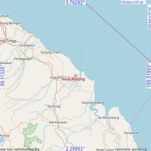
Teluk Nibung GPS coordinates[2]
3° 0' 3.6" North, 99° 48' 59.04" East
| Map corner | latitude | longitude |
|---|---|---|
| Upper-left | 3.70292°, | 99.11328° |
| Center: | 3.001°, | 99.8164° |
| Lower-right: | 2.29863°, | 100.51953° |
| Map W x H: | 156.1×156.1 km | = 97×97mi |
| max Lat: | 5.88969° ⇑2% North |
| Teluk Nibung: | 3.001° |
| min Lat: | ⇓98% South -10.934° |
| min Long | Teluk Nibung | max Long |
| 95.1345° | 99.8164° | 140.9419° |
| W 2.5%⇐ | ⇒97.5% E |
Elevation
Elevation of Teluk Nibung is 3 m = 10 ft, and this is 226.7 m = 744 ft below average elevation for this country.
| Max E: |
3185 m = 10449 ft | 99.4% |
| Avg. | 229.7 m = 754 ft | |
| Teluk Nibung | 3 m = 10 ft | |
Min E: |
-1 m = -3 ft | 0.6% |
See also: Indonesia elevation on elevation.city.
Geographical zone
Teluk Nibung is located in North Torrid zone (between Equator and Tropic of Cancer). Distance of Equator is 333.7 km =207.4 mi to South.| Distance of | km | miles | from Teluk Nibung |
|---|---|---|---|
| North Pole | 9673.4 | 6010.8 | to North |
| Arctic Circle | 7067.5 | 4391.5 | to North |
| Tropic Cancer | 2272.2 | 1411.9 | to North |
| Equator | 333.7 | 207.4 | to South |


Nearby cities:
15 places around Teluk Nibung: (largest is in red/bold)
• Aek Kanopan
51.2 km =31.8 mi,  200°
200°
• Bandar
106 km =65.9 mi,  183°
183°
• Kisaran
22.3 km =13.9 mi,  265°
265°
• Limapuluh
48.1 km =29.9 mi,  292°
292°
• Pane Tongah
94.3 km =58.6 mi,  263°
263°
• Parapat
104.9 km =65.2 mi,  248°
248°
• Pekan Bahapal
72.5 km =45 mi,  279°
279°
• Pematangsiantar
83.2 km =51.7 mi, 266°
• Rantau Prapat
78.8 km =49 mi,  160°
160°
• Rantauprapat
100.2 km =62.3 mi, 178°
• Sarimatondang
101.2 km =62.9 mi, 261°
• Sei Rampah
92.7 km =57.6 mi,  305°
305°
• Sondi
106.1 km =65.9 mi, 268°
• Tanjungbalai
4.2 km =2.6 mi,  205°
205°
• Tebingtinggi
81.2 km =50.5 mi,  296°
296°
Sources, notices
• [Note1] Compared only with cities in Indonesia existing in our database
• [Src1] Map data: © OpenStreetMap contributors (CC-BY-SA)
• [Src2] Other city data from geonames.org with taken over terms of usage.
• [Src3] Geographical zone / Annual Mean Temperature by Robert A. Rohde @ Wikipedia
