Gombong geodata
Gombong (Central Java) is a populated place; located in Indonesia in Asia/Jakarta (GMT+7) time zone. With population of 31,965 people, there are 305 cities with bigger population in this country. Compared to other cities in Indonesia, 58.2% of cities are located further ↑North; 65.9% of cities are located further →East and 74.1% of cities have higher elevation than Gombong. Note1


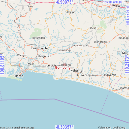
Gombong GPS coordinates[2]
7° 36' 25.992" South, 109° 30' 51.012" East
| Map corner | latitude | longitude |
|---|---|---|
| Upper-left | -6.90973°, | 108.81105° |
| Center: | -7.60722°, | 109.51417° |
| Lower-right: | -8.30357°, | 110.2173° |
| Map W x H: | 155×155 km | = 96.3×96.3mi |
| max Lat: | 5.88969° ⇑58.2% North |
| Gombong: | -7.60722° |
| min Lat: | ⇓41.8% South -10.934° |
| min Long | Gombong | max Long |
| 95.1345° | 109.51417° | 140.9419° |
| W 34.1%⇐ | ⇒65.9% E |
Elevation
Elevation of Gombong is 26 m = 85 ft, and this is 203.7 m = 668 ft below average elevation for this country.
| Max E: |
3185 m = 10449 ft | 74.1% |
| Avg. | 229.7 m = 754 ft | |
| Gombong | 26 m = 85 ft | |
Min E: |
-1 m = -3 ft | 25.9% |
See also: Indonesia elevation on elevation.city.
Geographical zone
Gombong is located in South Torrid zone (between Equator and Tropic of Capricorn). Distance of Equator is 845.8 km =525.6 mi to North.| Distance of | km | miles | from Gombong |
|---|---|---|---|
| Equator | 845.8 | 525.6 | to North |
| Tropic Capricorn | 1760.1 | 1093.7 | to South |
| Antarctic Circle | 6555.3 | 4073.3 | to South |
| South Pole | 9161.2 | 5692.5 | to South |


Nearby cities:
15 places around Gombong: (largest is in red/bold)
• Banjarnegara
30.9 km =19.2 mi,  40°
40°
• Banyumas
26.4 km =16.4 mi,  293°
293°
• Bayeman
32.5 km =20.2 mi,  271°
271°
• Binangun
30.5 km =19 mi,  284°
284°
• Brak
32.9 km =20.4 mi, 279°
• Gambolempuk
31.4 km =19.5 mi, 278°
• Gununglaban
31.3 km =19.4 mi, 273°
• Karangjati
32.2 km =20 mi, 275°
• Kebumen
16.8 km =10.4 mi,  113°
113°
• Kroya
29.7 km =18.5 mi,  264°
264°
• Papringan
31.5 km =19.6 mi, 291°
• Purbalingga
29.5 km =18.3 mi,  325°
325°
• Rawaseser
29.4 km =18.3 mi, 271°
• Sidasari
34.6 km =21.5 mi, 275°
• Sokaraja
29.9 km =18.6 mi,  303°
303°
Sources, notices
• [Note1] Compared only with cities in Indonesia existing in our database
• [Src1] Map data: © OpenStreetMap contributors (CC-BY-SA)
• [Src2] Other city data from geonames.org with taken over terms of usage.
• [Src3] Geographical zone / Annual Mean Temperature by Robert A. Rohde @ Wikipedia
