Drommahane geodata
Drommahane (Munster) is a populated place; located in Ireland in Europe/Dublin (GMT+1) time zone. With population of 872 people, there are 372 cities with bigger population in this country. Compared to other cities in Ireland, 90.7% of cities are located further ↑North; 81.2% of cities are located further →East and 93.5% of cities have lower elevation than Drommahane. Note1


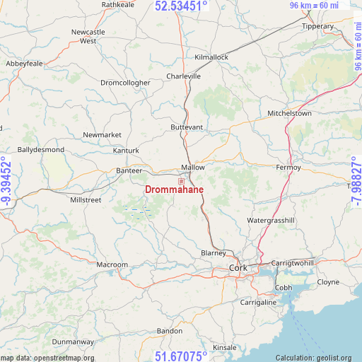
Drommahane GPS coordinates[2]
52° 6' 16.992" North, 8° 41' 29.004" West
| Map corner | latitude | longitude |
|---|---|---|
| Upper-left | 52.53451°, | -9.39452° |
| Center: | 52.10472°, | -8.69139° |
| Lower-right: | 51.67075°, | -7.98827° |
| Map W x H: | 96×96 km | = 59.7×59.7mi |
| max Lat: | 55.25° ⇑90.7% North |
| Drommahane: | 52.10472° |
| min Lat: | ⇓9.3% South 51.52487° |
| min Long | Drommahane | max Long |
| -10.26889° | -8.69139° | -6.04944° |
| W 18.8%⇐ | ⇒81.2% E |
Elevation
Elevation of Drommahane is 115 m = 377 ft, and this is 60.5 m = 198 ft above average elevation for this country.
| Max E: |
262 m = 860 ft | 6.5% |
| Drommahane | 115 m 377 ft | |
| Avg. | 54.5 m = 179 ft | |
Min E: |
0 m = 0 ft | 93.5% |
See also: Ireland elevation on elevation.city.
Geographical zone
Drommahane is located in North temperate zone (between Tropic of Cancer and the Arctic Circle). Distance of this North polar circle is 1607.7 km =999 mi to North.| Distance of | km | miles | from Drommahane |
|---|---|---|---|
| North Pole | 4213.6 | 2618.2 | to North |
| Arctic Circle | 1607.7 | 999 | to North |
| Tropic Cancer | 3187.6 | 1980.7 | to South |
| Equator | 5793.5 | 3599.9 | to South |


Nearby cities:
15 places around Drommahane: (largest is in red/bold)
• Blarney
20.9 km =13 mi,  155°
155°
• Buttevant
14.4 km =8.9 mi,  6°
6°
• Churchtown
18.2 km =11.3 mi,  350°
350°
• Courtbrack
15.6 km =9.7 mi,  168°
168°
• Doneraile
14.5 km =9 mi,  30°
30°
• Glanworth
24.5 km =15.2 mi,  68°
68°
• Grenagh
11.4 km =7.1 mi,  150°
150°
• Kanturk
15.8 km =9.8 mi,  295°
295°
• Killumney
26 km =16.2 mi, 173°
• Mallow
5.1 km =3.2 mi,  51°
51°
• Millstreet
25.7 km =16 mi,  258°
258°
• Newmarket
24.5 km =15.2 mi, 300°
• Tower
20.7 km =12.9 mi, 163°
• Watergrasshill
25.9 km =16.1 mi,  113°
113°
• Whitechurch
18.3 km =11.4 mi,  138°
138°
Sources, notices
• [Note1] Compared only with cities in Ireland existing in our database
• [Src1] Map data: © OpenStreetMap contributors (CC-BY-SA)
• [Src2] Other city data from geonames.org with taken over terms of usage.
• [Src3] Geographical zone / Annual Mean Temperature by Robert A. Rohde @ Wikipedia
