Loch Garman geodata
Loch Garman (Leinster) is a seat of a second-order administrative division; located in Ireland in Europe/Dublin (GMT+1) time zone. With population of 19,913 people, there are 19 cities with bigger population in this country. Compared to other cities in Ireland, 84.6% of cities are located further ↑North; 75.9% of cities are located further ←West and 97.2% of cities have higher elevation than Loch Garman. Note1


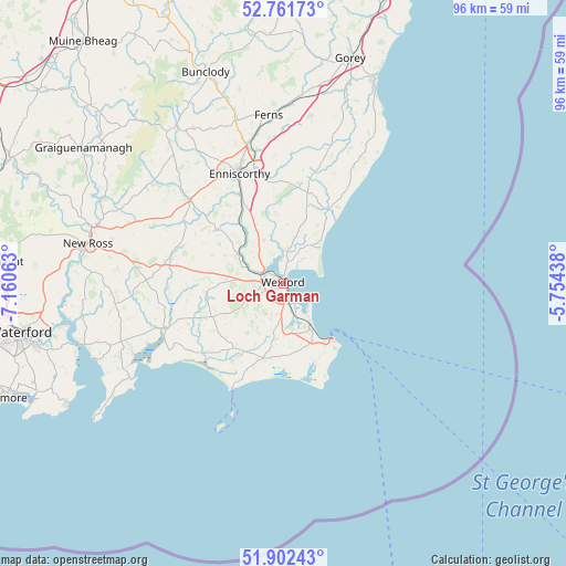
Loch Garman GPS coordinates[2]
52° 20' 3.012" North, 6° 27' 27" West
| Map corner | latitude | longitude |
|---|---|---|
| Upper-left | 52.76173°, | -7.16063° |
| Center: | 52.33417°, | -6.4575° |
| Lower-right: | 51.90243°, | -5.75438° |
| Map W x H: | 95.5×95.5 km | = 59.3×59.3mi |
| max Lat: | 55.25° ⇑84.6% North |
| Loch Garman: | 52.33417° |
| min Lat: | ⇓15.4% South 51.52487° |
| min Long | Loch Garman | max Long |
| -10.26889° | -6.4575° | -6.04944° |
| W 75.9%⇐ | ⇒24.1% E |
Elevation
Elevation of Loch Garman is 5 m = 16 ft, and this is 49.5 m = 162 ft below average elevation for this country.
| Max E: |
262 m = 860 ft | 97.2% |
| Avg. | 54.5 m = 179 ft | |
| Loch Garman | 5 m = 16 ft | |
Min E: |
0 m = 0 ft | 2.8% |
See also: Ireland elevation on elevation.city.
Geographical zone
Loch Garman is located in North temperate zone (between Tropic of Cancer and the Arctic Circle). Distance of this North polar circle is 1582.2 km =983.1 mi to North.| Distance of | km | miles | from Loch Garman |
|---|---|---|---|
| North Pole | 4188 | 2602.3 | to North |
| Arctic Circle | 1582.2 | 983.1 | to North |
| Tropic Cancer | 3213.1 | 1996.5 | to South |
| Equator | 5819 | 3615.8 | to South |


Nearby cities:
15 places around Loch Garman: (largest is in red/bold)
• Ballinroad
20.7 km =12.9 mi,  9°
9°
• Ballycanew
32.3 km =20.1 mi,  18°
18°
• Ballygerry
11.6 km =7.2 mi,  144°
144°
• Bunclody
38.1 km =23.7 mi,  339°
339°
• Castlebridge
5.8 km =3.6 mi, 5°
• Courtown
37.8 km =23.5 mi, 24°
• Enniscorthy
19.7 km =12.2 mi, 339°
• Ferns
28.4 km =17.6 mi,  354°
354°
• Ford
23.1 km =14.4 mi,  31°
31°
• Kilrane
12.3 km =7.6 mi,  146°
146°
• New Ross
33.3 km =20.7 mi,  282°
282°
• Passage East
37 km =23 mi,  251°
251°
• Piercetown
6 km =3.7 mi,  201°
201°
• Rosslare
8.2 km =5.1 mi, 142°
• Taghmon
13 km =8.1 mi,  263°
263°
Sources, notices
• [Note1] Compared only with cities in Ireland existing in our database
• [Src1] Map data: © OpenStreetMap contributors (CC-BY-SA)
• [Src2] Other city data from geonames.org with taken over terms of usage.
• [Src3] Geographical zone / Annual Mean Temperature by Robert A. Rohde @ Wikipedia
