Piercetown geodata
Piercetown (Leinster) is a populated place; located in Ireland in Europe/Dublin (GMT+1) time zone. With population of 555 people, there are 498 cities with bigger population in this country. Compared to other cities in Ireland, 86% of cities are located further ↑North; 74.6% of cities are located further ←West and 64.5% of cities have higher elevation than Piercetown. Note1


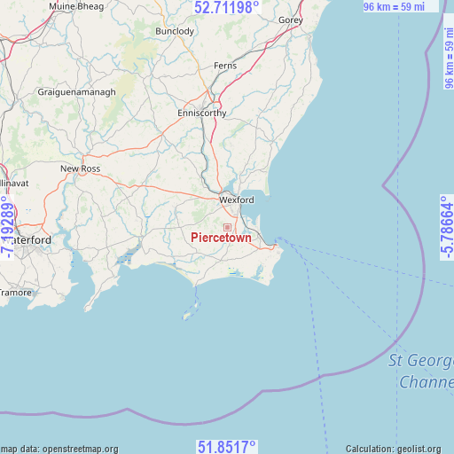
Piercetown GPS coordinates[2]
52° 17' 2.148" North, 6° 29' 23.172" West
| Map corner | latitude | longitude |
|---|---|---|
| Upper-left | 52.71198°, | -7.19289° |
| Center: | 52.28393°, | -6.48977° |
| Lower-right: | 51.8517°, | -5.78664° |
| Map W x H: | 95.7×95.7 km | = 59.5×59.5mi |
| max Lat: | 55.25° ⇑86% North |
| Piercetown: | 52.28393° |
| min Lat: | ⇓14% South 51.52487° |
| min Long | Piercetown | max Long |
| -10.26889° | -6.48977° | -6.04944° |
| W 74.6%⇐ | ⇒25.4% E |
Elevation
Elevation of Piercetown is 32 m = 105 ft, and this is 22.5 m = 74 ft below average elevation for this country.
| Max E: |
262 m = 860 ft | 64.5% |
| Avg. | 54.5 m = 179 ft | |
| Piercetown | 32 m = 105 ft | |
Min E: |
0 m = 0 ft | 35.5% |
See also: Ireland elevation on elevation.city.
Geographical zone
Piercetown is located in North temperate zone (between Tropic of Cancer and the Arctic Circle). Distance of this North polar circle is 1587.7 km =986.6 mi to North.| Distance of | km | miles | from Piercetown |
|---|---|---|---|
| North Pole | 4193.6 | 2605.8 | to North |
| Arctic Circle | 1587.7 | 986.6 | to North |
| Tropic Cancer | 3207.5 | 1993 | to South |
| Equator | 5813.4 | 3612.3 | to South |


Nearby cities:
15 places around Piercetown: (largest is in red/bold)
• Ballinroad
26.6 km =16.5 mi,  12°
12°
• Ballycanew
38.3 km =23.8 mi,  19°
19°
• Ballygerry
9.8 km =6.1 mi,  113°
113°
• Castlebridge
11.7 km =7.3 mi, 13°
• Dunmore East
37.7 km =23.4 mi,  246°
246°
• Enniscorthy
24.6 km =15.3 mi,  349°
349°
• Ferns
33.9 km =21.1 mi,  358°
358°
• Ford
29.1 km =18.1 mi,  29°
29°
• Kilrane
10.2 km =6.3 mi,  117°
117°
• Loch Garman
6 km =3.7 mi, 21°
• New Ross
32.8 km =20.4 mi,  292°
292°
• Passage East
33.5 km =20.8 mi,  259°
259°
• Rosslare
7.2 km =4.5 mi,  97°
97°
• Taghmon
11.5 km =7.1 mi, 291°
• Waterford
42.4 km =26.3 mi,  266°
266°
Sources, notices
• [Note1] Compared only with cities in Ireland existing in our database
• [Src1] Map data: © OpenStreetMap contributors (CC-BY-SA)
• [Src2] Other city data from geonames.org with taken over terms of usage.
• [Src3] Geographical zone / Annual Mean Temperature by Robert A. Rohde @ Wikipedia
