Ballyclerahan geodata
Ballyclerahan (Munster) is a populated place; located in Ireland in Europe/Dublin (GMT+1) time zone. With population of 807 people, there are 400 cities with bigger population in this country. Compared to other cities in Ireland, 81.8% of cities are located further ↑North; 57.5% of cities are located further →East and 79.1% of cities have lower elevation than Ballyclerahan. Note1


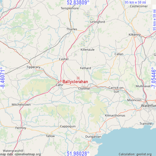
Ballyclerahan GPS coordinates[2]
52° 24' 40.572" North, 7° 45' 27.324" West
| Map corner | latitude | longitude |
|---|---|---|
| Upper-left | 52.83809°, | -8.46071° |
| Center: | 52.41127°, | -7.75759° |
| Lower-right: | 51.98028°, | -7.05446° |
| Map W x H: | 95.4×95.4 km | = 59.3×59.3mi |
| max Lat: | 55.25° ⇑81.8% North |
| Ballyclerahan: | 52.41127° |
| min Lat: | ⇓18.2% South 51.52487° |
| min Long | Ballyclerahan | max Long |
| -10.26889° | -7.75759° | -6.04944° |
| W 42.5%⇐ | ⇒57.5% E |
Elevation
Elevation of Ballyclerahan is 87 m = 285 ft, and this is 32.5 m = 107 ft above average elevation for this country.
| Max E: |
262 m = 860 ft | 20.9% |
| Ballyclerahan | 87 m 285 ft | |
| Avg. | 54.5 m = 179 ft | |
Min E: |
0 m = 0 ft | 79.1% |
See also: Ireland elevation on elevation.city.
Geographical zone
Ballyclerahan is located in North temperate zone (between Tropic of Cancer and the Arctic Circle). Distance of this North polar circle is 1573.6 km =977.8 mi to North.| Distance of | km | miles | from Ballyclerahan |
|---|---|---|---|
| North Pole | 4179.5 | 2597 | to North |
| Arctic Circle | 1573.6 | 977.8 | to North |
| Tropic Cancer | 3221.7 | 2001.9 | to South |
| Equator | 5827.6 | 3621.1 | to South |


Nearby cities:
15 places around Ballyclerahan: (largest is in red/bold)
• Ardfinnan
13.6 km =8.5 mi,  215°
215°
• Cahir
11.8 km =7.3 mi,  251°
251°
• Callan
28.9 km =18 mi,  59°
59°
• Cappoquin
30.1 km =18.7 mi,  192°
192°
• Carrick-on-Suir
24.4 km =15.2 mi,  106°
106°
• Cashel
14.5 km =9 mi,  323°
323°
• Cluain Meala
7.2 km =4.5 mi,  149°
149°
• Fethard
7.7 km =4.8 mi,  35°
35°
• Holycross
26.4 km =16.4 mi,  344°
344°
• Killenaule
18.4 km =11.4 mi,  18°
18°
• Kilsheelan
13.5 km =8.4 mi, 114°
• Piltown
29 km =18 mi,  102°
102°
• Thurles
30.2 km =18.8 mi,  354°
354°
• Tipperary
27.9 km =17.3 mi,  284°
284°
• Twomileborris
29.1 km =18.1 mi,  5°
5°
Sources, notices
• [Note1] Compared only with cities in Ireland existing in our database
• [Src1] Map data: © OpenStreetMap contributors (CC-BY-SA)
• [Src2] Other city data from geonames.org with taken over terms of usage.
• [Src3] Geographical zone / Annual Mean Temperature by Robert A. Rohde @ Wikipedia
