Holycross geodata
Holycross (Munster) is a populated place; located in Ireland in Europe/Dublin (GMT+1) time zone. With population of 714 people, there are 427 cities with bigger population in this country. Compared to other cities in Ireland, 75% of cities are located further ↑North; 60.3% of cities are located further →East and 81.4% of cities have lower elevation than Holycross. Note1


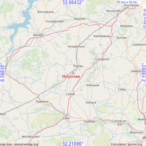
Holycross GPS coordinates[2]
52° 38' 22.992" North, 7° 51' 47.016" West
| Map corner | latitude | longitude |
|---|---|---|
| Upper-left | 53.06432°, | -8.56618° |
| Center: | 52.63972°, | -7.86306° |
| Lower-right: | 52.21096°, | -7.15993° |
| Map W x H: | 94.9×94.9 km | = 59×59mi |
| max Lat: | 55.25° ⇑75% North |
| Holycross: | 52.63972° |
| min Lat: | ⇓25% South 51.52487° |
| min Long | Holycross | max Long |
| -10.26889° | -7.86306° | -6.04944° |
| W 39.7%⇐ | ⇒60.3% E |
Elevation
Elevation of Holycross is 91 m = 299 ft, and this is 36.5 m = 120 ft above average elevation for this country.
| Max E: |
262 m = 860 ft | 18.6% |
| Holycross | 91 m 299 ft | |
| Avg. | 54.5 m = 179 ft | |
Min E: |
0 m = 0 ft | 81.4% |
See also: Ireland elevation on elevation.city.
Geographical zone
Holycross is located in North temperate zone (between Tropic of Cancer and the Arctic Circle). Distance of this North polar circle is 1548.2 km =962 mi to North.| Distance of | km | miles | from Holycross |
|---|---|---|---|
| North Pole | 4154.1 | 2581.2 | to North |
| Arctic Circle | 1548.2 | 962 | to North |
| Tropic Cancer | 3247.1 | 2017.7 | to South |
| Equator | 5853 | 3636.9 | to South |


Nearby cities:
15 places around Holycross: (largest is in red/bold)
• Ballyclerahan
26.4 km =16.4 mi,  164°
164°
• Borrisoleigh
13.9 km =8.6 mi,  334°
334°
• Cahir
29.5 km =18.3 mi,  187°
187°
• Cappamore
32 km =19.9 mi,  264°
264°
• Cashel
13.9 km =8.6 mi, 186°
• Doon
26.1 km =16.2 mi, 261°
• Fethard
22.4 km =13.9 mi,  148°
148°
• Freshford
33 km =20.5 mi,  71°
71°
• Killenaule
15.2 km =9.4 mi,  121°
121°
• Rathdowney
30.6 km =19 mi,  38°
38°
• Templemore
17.3 km =10.7 mi,  6°
6°
• Thurles
6.2 km =3.9 mi, 41°
• Tipperary
27.1 km =16.8 mi,  226°
226°
• Twomileborris
10.3 km =6.4 mi, 69°
• Urlingford
20.9 km =13 mi,  64°
64°
Sources, notices
• [Note1] Compared only with cities in Ireland existing in our database
• [Src1] Map data: © OpenStreetMap contributors (CC-BY-SA)
• [Src2] Other city data from geonames.org with taken over terms of usage.
• [Src3] Geographical zone / Annual Mean Temperature by Robert A. Rohde @ Wikipedia
